
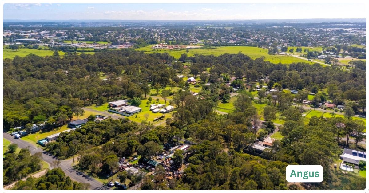
Angus doesn’t really function as a suburb yet, in the sense most people mean the word. It’s 13.6 square kilometres of Blacktown’s North West Growth Corridor, still mostly acreage and paddock, carved off from Marsden Park and Riverstone and given its own name in November 2020 after a Blacktown Shire president from a century ago. Some parcels are already zoned residential and selling as house-and-land; others are marked “rezoning anticipated” for as late as 2026; a fair amount is still rural land with a single dwelling and 20 hectares around it. Buying here right now means buying into a suburb mid-transformation, not a finished product, and that distinction matters more here than almost anywhere else on this list.
Angus Boundary and Location Map
Angus sits roughly 41 kilometres northwest of the Sydney CBD in the Blacktown City Council area, within the broader North West Growth Area. It borders Riverstone and Riverstone West to the north and east, Grantham Farm and Marsden Park to the south, and Nirimba Fields to the southwest, on Darug country (NSW Spatial Services, suburb boundary confirmed August 2026).
Quick Facts
| LGA | Blacktown City Council |
| Postcode | 2765 (shared with Riverstone, Grantham Farm and Marsden Park) |
| Population | 384 residents (2021 Census, ABS SAL10060). This isn’t a shrinking suburb; the boundary itself is new (gazetted November 2020), so there’s no genuinely comparable earlier figure to trend against |
| Growth Rate | Not meaningfully trackable yet given the recent boundary change, but expect this to rise as remaining rural lots are rezoned and subdivided over the coming years |
| Distance from CBD | Approximately 41 km northwest |
| Character | Transitional growth-corridor suburb, part rural acreage, part rezoned residential and industrial land, still being built out |
| Median House Price | Not reliably available. One data source shows a 12-month median of $176,000 (down 29.6% year-on-year), but with so few dwellings and such a mix of vacant land, rural lots and finished houses changing hands, that figure almost certainly reflects a handful of unusual sales rather than a genuine market price. Land listings currently range from around $549,000 for small residential-zoned blocks to several million dollars for larger development sites (accessed August 2026) |
| Median Unit Price | Not applicable. There is no unit stock in Angus; 96.7% of dwellings are separate houses (2021 Census) |
| Transport | No train station in Angus itself. Riverstone station, on the Richmond branch of the T1 North Shore & Western Line, is the nearest option, a short drive away |
| Crime Rate (LGA) | Blacktown LGA: violent crime 1,294.8 per 100,000 (ranked 57th-highest of 118 NSW LGAs, roughly mid-table, up slightly from 1,262.2 the year before); property crime 1,401.6 per 100,000 (ranked 71st of 118, in the safer half, up slightly from 1,350.4 the year before) (BOCSAR, April 2025-March 2026) |
| Childcare Availability | Tight within Angus itself; none operate inside the suburb. Riverstone, a short drive away, has several long day care and preschool options (CareforKids.com.au, accessed August 2026) |
| School Zone Quality | No school inside Angus. Riverstone Public School and Riverstone High School are the nearest government options |
| Parks & Recreation | Mostly informal, rural-character open space at present; established parks and sporting facilities are concentrated in neighbouring Riverstone and Marsden Park |
| Shopping | No retail within Angus; Riverstone town centre and Marsden Park’s shopping centre cover day to day needs |
| Health | No GP within Angus; Riverstone has several general practices, and Blacktown Hospital is the nearest major public hospital |
| Best For | Land buyers, developers and acreage lifestyle buyers comfortable with a transitional area still years from feeling like a finished suburb |
What Makes Angus Special
A Suburb Named After a Man, Not a Marketing Brief
Angus takes its name from John Angus, president of Blacktown Shire Council from 1917 to 1920, one of six new suburb names Blacktown City gazetted in November 2020 alongside Grantham Farm, Melonba, Nirimba Fields, Richards and Tallawong. That’s a genuinely different origin story to the developer-branded estate names that dominate this growth corridor, and it’s a useful reminder that Angus is an administrative creation carved from Marsden Park and Riverstone, not a place that grew organically under its own identity.
A Genuine Land-Banking Play, Not a Finished Suburb
What sets Angus apart from most Sydney suburb profiles is that there’s honestly not that much suburb here yet. Current listings mix rezoned residential blocks, land still marked “drafted to be rezoned,” and general industrial sites, all within the same small area. That’s the real point of difference: this is a suburb for buyers thinking in years and land titles, not for anyone expecting a walkable town centre on day one.
What Is It Like Living Here?
With 384 residents across 120 occupied dwellings, Angus is less a community with its own rhythm and more a scattering of rural and semi-rural households waiting for the growth corridor to catch up to them. Locals lean noticeably older (median age 45) and more established than the young-family growth suburbs nearby, and a genuinely large share still farm the land or hold onto acreage that hasn’t yet been subdivided.
Transport
There’s no train station inside Angus. Riverstone, on the Richmond branch of the T1 North Shore & Western Line, is the nearest, a short drive away, with services running through to Blacktown and on to the CBD. There’s no dedicated local bus route mapped specifically to Angus at this stage, reflecting how little of the suburb is currently built out; residents largely rely on a car for anything beyond the immediate property. That’s likely to change as residential rezoning proceeds, but there’s no confirmed timeline for new public transport infrastructure reaching Angus itself as of 2026.
Healthcare
There’s no GP or medical centre within Angus. In the adjacent suburb of Marsden Park, there is Castle Medical at the Ellara Shopping Centre. Riverstone has several general practices a short drive away, and Blacktown Hospital is the nearest major public hospital, covering emergency care and the bulk of specialist services for the wider area.
Schools and Childcare
Angus has no school of its own. Riverstone Public School and Riverstone High School are the nearest government options, both a drive rather than a walk away. Childcare follows the same pattern: nothing operates inside Angus itself, but Riverstone has a genuine spread of long day care and preschool services, including a preschool attached to Riverstone Public School. Families moving here now should plan around a daily drive for both school and care, at least until more of the suburb is built out.
Industry & Work Life
Managers (19.0%), professionals (13.3%) and trades workers (13.3%) top the occupation list for Angus residents (2021 Census), with supermarket and grocery, and road freight transport, the two most common specific industries. That mix reflects the area’s semi-rural, semi-industrial character: some residents run the land they live on, others commute to the logistics and warehouse precincts that increasingly define this stretch of the North West Growth Corridor. Median personal weekly income sits at $757, below the NSW median of $813, though median household income of $1,890 a week points to multiple earners per household being common.
Shopping & Eating Out
There’s no shopping of any kind within Angus. Riverstone’s town centre, currently the subject of a major state-led rezoning that would add 3,600 homes and new retail space, is the closest option, with the larger Home Co. Marsden Park shopping centre a short drive further south or a little closer to the west, is the new Elara Village Shopping Centre. Neither is inside Angus, so anyone buying here should factor a drive into daily errands for the foreseeable future.
Attractions, Parks and Natural Spaces
Angus doesn’t have established public parks or sporting facilities of its own yet; its current character is closer to open rural land than landscaped recreation space. The nearest established green space and sporting grounds sit in Riverstone and Marsden Park. As rezoning proceeds under the North West Growth Area precinct plans, new local parks are expected as part of the standard subdivision requirements, though none are confirmed as delivered within Angus as of 2026.
Crime and Safety
No suburb-level crime data exists for Angus specifically; BOCSAR reports only at the local government area level, and Blacktown LGA is large and varied, covering everything from established suburban centres to this kind of transitional growth-corridor land. For the LGA as a whole in the year to March 2026, the violent crime rate was 1,294.8 incidents per 100,000 people, ranking Blacktown 57th-highest of 118 NSW LGAs (roughly mid-table) and up slightly from 1,262.2 the year before. Property crime sat at 1,401.6 incidents per 100,000, ranking 71st of 118 (in the safer half of the state) and up slightly from 1,350.4 the year before. There’s no suburb-specific data to say how a sparsely populated, low-traffic area like Angus compares to the LGA average, only a reasonable inference that a suburb this thin on both people and property is unlikely to be a major driver of either figure (BOCSAR, April 2025-March 2026).
Realty Market
Angus doesn’t have a conventional housing market yet, and treating it like one would be misleading. The suburb mixes established rural dwellings on multi-hectare blocks, land already rezoned R2 or R3 residential and being marketed for house-and-land packages, and industrial-zoned parcels awaiting general industrial development. Current listings span roughly $549,000 for small rezoned residential blocks up to several million dollars for larger development-ready sites, with at least one listing noting rezoning anticipated for Q3 2026.
A reported median house sale price of $176,000 for the past 12 months should be treated with real scepticism: with only 120 occupied dwellings in the whole suburb and a mix of land and housing sales feeding into the same dataset, a single unusual transaction can distort the figure badly. There’s no reliable rental market data either, given the tiny and mixed housing stock; the 2021 Census recorded a median weekly rent of $350 across the 24 rented dwellings that existed at that time, but that figure is now several years old and unlikely to reflect current conditions.
Our Honest Verdict
Angus is likely to appeal most to land buyers, developers and acreage lifestyle seekers who understand they’re buying into a suburb mid-transformation, not a finished one, and who are comfortable with years of driving to Riverstone or Marsden Park for school, shopping, healthcare and public transport. It is a considerably weaker fit for anyone wanting an established community with schools, shops and transport already in place, or for buyers who need reliable, comparable price data before committing.
Grantham Farm, immediately to the south and gazetted at the same time as Angus, is the genuine comparison suburb here: same postcode, same growth corridor, but already home to 3,669 residents (2021 Census) and an active residential market with a 2025 median house price of $1.08 million. The two suburbs started from the same administrative moment in November 2020 and are now years apart in how developed they feel, which says a lot about how quickly, or slowly, this kind of rezoning plays out.
Frequently Asked Questions
Is Angus a good suburb to buy in right now?
It depends entirely on what you’re buying for. As a place to live day to day, Angus currently has no schools, shops, GPs or public transport of its own, all a drive away in Riverstone or Marsden Park. As a land or development play within Sydney’s North West Growth Corridor, it’s an active market with rezoning proceeding on parts of the suburb, though specific dates like the “Q3 2026” mentioned on some listings aren’t confirmed government timelines.
Why did Angus’s population drop so dramatically since 2016?
It didn’t, in the way that figure implies. Angus was only gazetted as its own suburb in November 2020; the “Angus” boundary used for the 2016 Census referred to a different, larger area that has since been split into several new suburbs, including Angus, Grantham Farm and Nirimba Fields. Comparing 2016 and 2021 population figures for “Angus” is comparing two different boundaries, not tracking a real population collapse.
Does Angus have a train station?
No. The nearest is Riverstone station on the Richmond branch of the T1 North Shore & Western Line, a short drive away.
References
- Australian Bureau of Statistics, 2021 Census Community Profile, Angus (SAL10060), census date 10 August 2021, data accessed August 2026.
- NSW Government, gazettal notice and Mirage News report on new Blacktown City suburb names, effective 6 November 2020, accessed August 2026.
- PropertyValue.com.au, Angus NSW 2765 suburb profile, median house price and 12-month change, accessed August 2026.
- CommercialRealEstate.com.au, Angus NSW 2765 land and development listings, accessed August 2026.
- NSW Bureau of Crime Statistics and Research (BOCSAR), LGA ranking for violent and property offences, April 2016 to March 2026, Blacktown LGA data, local dataset accessed August 2026.
- NSW Spatial Services, NSW Administrative Boundaries Theme, suburb boundary query for Angus, accessed August 2026.
- CareforKids.com.au, childcare service listings for Riverstone NSW 2765, accessed August 2026.
- NSW Department of Planning, Housing and Infrastructure, North West Growth Area Riverstone and Riverstone West precinct plans, accessed August 2026.
- The Urban Developer, “Plan for 3600-Home Rezoning at Blacktown Moves Ahead,” Riverstone Town Centre rezoning, accessed August 2026.
- InTheSuburbs.com.au, Grantham Farm NSW 2765 suburb profile, population and median price, accessed August 2026.
For more on the area, see the complete list of Sydney suburbs by municipality and the broader Sydney regions overview.