
Ask ten Sydneysiders where they live and you’ll get ten different answers. The Eastern Suburbs. The Inner West. The Shire. Out west. The North Shore. None of these are official places. No council governs them. No map draws their edges with precision. But every local knows exactly what they mean.
Sydney runs on two parallel systems for describing itself. The informal one comes first: the regions locals reach for in everyday conversation, shaped by geography, culture and decades of habit. The formal one sits underneath: the planning districts and Local Government Areas that determine where housing gets built, how transport is funded, and what the city looks like in 2056.
This guide covers both. It explains the informal regions Sydneysiders actually use, the 658 suburbs spread across them, and the formal Three Cities and Five Districts framework the NSW Government uses to plan the city’s growth.
For a full breakdown of suburbs by council, see the Sydney Suburbs by Municipality list.
Population
More than 5.6 million
Local Gov. Areas
33 LGAs
Planning Cities
3 Cities
Districts
5 Districts
Quick Reference
Sydney at a Glance
Ten informal regions, one very large city. Here is how each part of Sydney identifies itself.
Informal Regions: Known For
- CBD & Inner City: The original settlement; the CBD, Haymarket, Pyrmont, Barangaroo, The Rocks. Locals call it “the city” or “town.”
- Inner West: Terrace houses, craft breweries, bohemian culture, off-leash dogs, cafe-centric lifestyle. Extends west to Strathfield.
- South Sydney: The industrial heartland turned urban renewal zone. Redfern, Alexandria, Green Square, Mascot, Botany.
- Eastern Suburbs: Coastal cliffs, beach culture, some of Sydney’s most expensive addresses. Bondi to La Perouse.
- St George: Established family suburbs along the Georges River and Botany Bay. Rockdale, Kogarah, Hurstville.
- Sutherland Shire: “The Shire.” Fiercely proud, coastal, south of the Georges River. Cronulla, Miranda, Sutherland.
- North Shore: Leafy streets, harbour views, private schools. Follows the T1 spine from the Bridge to Hornsby.
- Northern Beaches: The peninsula from Manly to Palm Beach. No rail, fierce local loyalty, surf culture.
- Northern Suburbs: The connector region. Ryde, Macquarie Park, Eastwood, Epping. Tech precincts, Macquarie University, exceptional Asian dining.
- Hills District: Rolling hills, master-planned estates, family suburbs north of the M2. Castle Hill, Rouse Hill, Kellyville.
- Western Sydney: The multicultural, rapidly expanding heart of modern Sydney. Parramatta to Penrith, Liverpool to Campbelltown. Includes Canterbury-Bankstown.
Sydney by the Numbers
The Scale of the City
Sydney is a genuinely large city, and the numbers reflect that. A few that tend to surprise people:
Suburbs
658
Coastline
~80 km
Beaches
100+
Surf Beaches
~70
Total Area
12,369 km2
LGAs
33
The coastline runs roughly 80 kilometres from Palm Beach in the north to Cronulla and the edge of Royal National Park in the south. Of the 100-plus beaches along that stretch, around 70 are patrolled surf beaches.
Western Sydney Airport, opening in October 2026, will be the first new international airport serving Sydney in more than 80 years. It is the largest piece of transport infrastructure the city has seen in a generation.
Informal Regions
How Sydneysiders Describe Their City
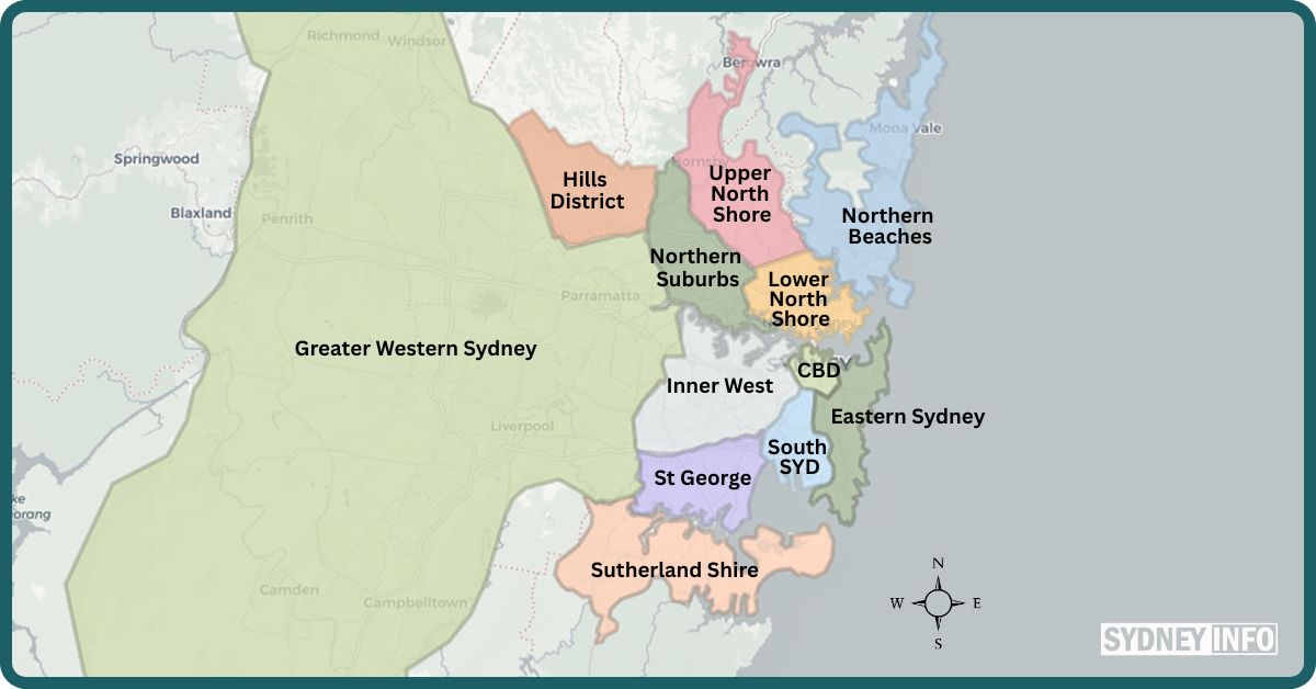
Long before government planners drew formal boundaries, Sydneysiders developed their own vocabulary for describing the city’s distinct pockets. These informal regions have no administrative bodies, and their edges are deliberately fuzzy. They describe a character and a location at the same time. And they’re the language locals use every day.
CBD & Inner City
The heart of Sydney and its original settlement: the CBD plus the dense inner suburbs of the City of Sydney LGA. Locals call it “the city” or “town,” rarely the CBD. Bounded roughly by the Harbour to the north, Central Station to the south, Darling Harbour to the west and Woolloomooloo to the east.
Major suburbs: Sydney CBD, Haymarket, Pyrmont, Barangaroo, The Rocks, Darling Harbour
Inner West
West of the CBD, south of the Parramatta River, north of the Cooks River, extending west to Strathfield. Terrace houses, craft breweries, bohemian culture and a heavy cafe-centric lifestyle. The Inner West has a strong identity and its residents tend to have strong opinions about it.
Major suburbs: Newtown, Balmain, Leichhardt, Marrickville, Glebe, Strathfield, Ashfield, Dulwich Hill, Rozelle, Annandale
Fuzzy edges: Glebe sits between Inner West and CBD conversations. Strathfield marks the western limit.
South Sydney
Directly south of Central Station, between the Eastern Suburbs to the east and the Inner West to the west, extending to the northern bank of the Cooks River. The historic working-class and industrial heartland, now heavily gentrified into warehouse apartments, design studios and high-density urban hubs.
Major suburbs: Redfern, Alexandria, Waterloo, Zetland (Green Square), Mascot, Botany, Rosebery, Beaconsfield
Fuzzy edges: Erskineville sits on the border with the Inner West. Kensington is sometimes grouped with the Eastern Suburbs.
Eastern Suburbs
East of the CBD and South Sydney, stretching to the Pacific Ocean coastline from South Head in the north to La Perouse in the south. Harbour views, coastal walks, high-end real estate, surf culture and affluent lifestyle. Point Piper has Australia’s highest median house price at around $17.3 million.
Major suburbs: Bondi Beach, Bondi Junction, Coogee, Bronte, Tamarama, Maroubra, Double Bay, Paddington, Rose Bay, Vaucluse, Woollahra, Randwick
Fuzzy edges: Maroubra and Kingsford are sometimes counted as Eastern Suburbs, sometimes as South Sydney.
St George
West and south of the Cooks River, north of the Georges River, east of the M5 corridor. Established, family-oriented residential suburbs with access to Botany Bay’s calm waters and strong culinary diversity. Hurstville is the regional commercial centre.
Major suburbs: Rockdale, Kogarah, Hurstville, Sans Souci, Wolli Creek, Blakehurst, Brighton-Le-Sands, Bexley, Oatley
Fuzzy edges: The northern edge overlaps with Bayside. The western edge drifts toward Canterbury-Bankstown around Bexley.
Sutherland Shire
South of the Georges River, east to the ocean at Cronulla, south into the Royal National Park. Known as “The Shire” by locals, who view it almost as a separate entity from the rest of Sydney. A fiercely proud, insular and distinct coastal identity. Cronulla was named Australia’s best beach in 2026.
Major suburbs: Cronulla, Miranda, Sutherland, Caringbah, Menai, Engadine, Gymea, Bundeena
Fuzzy edges: The northern boundary with St George around Mortdale and Penshurst is the main overlap zone.
North Shore
North of the Sydney Harbour Bridge, following the T1 train line spine to Hornsby. Bounded by the Lane Cove River to the west and Middle Harbour to the east. Leafy, manicured and prestigious. The Lower North Shore is urban and harbour-facing; the Upper North Shore features grand family estates and private school corridors.
Major suburbs: North Sydney, Mosman, Chatswood, Lane Cove, Neutral Bay, Cremorne, Kirribilli, Gordon, Wahroonga, Hornsby, Pymble, St Ives
Fuzzy edges: Chatswood sits on the boundary between North Shore and Northern Suburbs conversations.
Northern Beaches
Northeast of the city, from Manly up the peninsula to Palm Beach, bounded by Middle Harbour and Garigal National Park to the west. “The Insular Peninsula.” A laid-back, outdoor-focused surf culture where locals rarely feel the need to cross the Roseville or Spit bridges. No rail line. The strongest local identity of any Sydney region.
Major suburbs: Manly, Dee Why, Brookvale, Mona Vale, Avalon, Palm Beach, Narrabeen, Collaroy, Freshwater, Newport
Fuzzy edges: Seaforth and Balgowlah are sometimes counted as Lower North Shore. The Spit Bridge is both physical and symbolic boundary.
Northern Suburbs
North of the Parramatta River, west of the Lane Cove River, south of the M2 Motorway. The connector between the North Shore and the Hills District: a region defined by major tech and biomedical precincts, Macquarie University, and some of Sydney’s best Asian dining. Macquarie Park is Australia’s largest non-CBD office market with over 47,000 workers.
Major suburbs: Ryde, Epping, Eastwood, Macquarie Park, Carlingford, North Ryde, Meadowbank, West Ryde, Ermington
Fuzzy edges: Epping sits between Northern Suburbs and Hills District. Chatswood is sometimes claimed by both this region and the North Shore.
Hills District
North of the M2 Motorway, extending northwest to the semi-rural fringe. Rolling hills, sprawling family blocks, massive master-planned estates and a car-oriented culture. The Sydney Metro Northwest opened in 2019 and began connecting the Hills to the city, though Castle Hill remains the commercial hub for most residents.
Major suburbs: Castle Hill, Baulkham Hills, Rouse Hill, Bella Vista, Kellyville, Winston Hills, Norwest, Box Hill, Dural
Fuzzy edges: Pennant Hills sits on the boundary with the Upper North Shore. The Hills is sometimes grouped under Western Sydney in planning documents.
Western Sydney
The multicultural, rapidly expanding heart of modern Sydney. Starting west of Strathfield and Olympic Park, running to the Nepean River at Emu Plains. Encompasses Parramatta (the second CBD), Canterbury-Bankstown, the Greater West and the South West (Macarthur). More than two million people. Western Sydney Airport opens October 2026.
Major suburbs: Parramatta, Blacktown, Bankstown, Canterbury, Penrith, Liverpool, Campbelltown, Camden, Fairfield, Auburn, Cabramatta, Merrylands
Fuzzy edges: The eastern limit at Strathfield/Olympic Park is debated. At the western edge, Lapstone marks where Sydney ends and the Blue Mountains begin.
Good to Know
These informal regions have no fixed boundaries and no administrative function. Some overlap significantly: Canterbury-Bankstown, for instance, is variously counted as Inner South West, South Western Sydney or Greater Western Sydney depending on the document. When Sydneysiders use these names, they’re describing a character and a location at the same time.
Context
How Sydney Compares to Other Australian Cities
Sydney is less centralised than Brisbane or Perth, where a single CBD dominates the metropolitan geography. The NSW Government has actively pursued decentralisation, with Parramatta designated as Sydney’s second CBD. Major banks and government agencies have relocated to Parramatta Square, and the precinct now functions as a genuine commercial centre rather than a satellite office park.
The opening of Western Sydney Airport in October 2026 is the largest structural shift in Sydney’s geography in decades. It is the first new international airport serving the city in more than 80 years. Terminal construction was completed in June 2025, seven months ahead of schedule and within the $5.3 billion budget. Cargo flights begin in July 2026, with passenger services from 26 October 2026. More than $21.6 billion in private investment has been committed to the surrounding Aerotropolis precinct at Badgerys Creek.
Sydney’s population grew at 1.4% in 2024-25, slower than Perth (2.4%), Brisbane (2.1%) and Melbourne (2.0%). It remains Australia’s largest city at more than 5.6 million people. Within Greater Sydney, Camden is the fastest-growing LGA, projected to grow 172% by 2040 as greenfield development continues across the south-west corridor.
Formal Framework
The Metropolis of Three Cities with Five Districts
In 2018, the Greater Sydney Commission released A Metropolis of Three Cities, a 40-year regional plan to manage Sydney’s growth to 2056. The plan formally restructures Greater Sydney into three “cities”, each anchored by a major economic centre, and five more precisely defined planning districts.
The successor to this plan, known as The Sydney Plan, completed public consultation in February 2026 after an exhibition period from December 2025. It has not yet been finalised or adopted. Until it is, the 2018 framework remains the operative planning document across all levels of government.
The five districts are the boundaries used for land use decisions, transport investment, housing targets and infrastructure planning.
Map: Three Cities & Five Districts


Quick Reference
At a Glance: District Summary
- Eastern City District: 9 LGAs · Eastern Harbour City · Centre: Sydney CBD
- North District: 9 LGAs · Eastern Harbour City · Centres: North Sydney, Chatswood
- South District: 3 LGAs · Eastern Harbour City · Centres: Hurstville, Bankstown
- Central City District: 4 LGAs · Central River City · Centre: Parramatta
- Western City District: 8 LGAs · Western Parkland City · Centres: Penrith, Liverpool, Campbelltown
The Metropolis of Three Cities
Eastern Harbour City
Centre: Sydney CBD
The established eastern city, including the CBD, Inner West, Eastern Suburbs, North Shore, Northern Beaches, St George and Sutherland. The most economically productive and densely developed of the three cities, anchored by the global Harbour CBD.
Central River City
Centre: Parramatta
The middle city, covering Greater Western Sydney suburbs from Hornsby and Rouse Hill south through Blacktown, Fairfield and Bankstown to Sydney Olympic Park. Parramatta is the anchor and Sydney’s designated second CBD, with major banks and government agencies now headquartered at Parramatta Square.
Western Parkland City
Centres: Penrith · Liverpool · Campbelltown
The emerging western city, covering the remainder of Greater Western Sydney from Penrith and the Blue Mountains south through Liverpool and Campbelltown-Macarthur to Wollondilly. Western Sydney Airport at Badgerys Creek, opening October 2026, is the major catalyst for growth here. The surrounding Aerotropolis has attracted more than $21.6 billion in committed private investment.
The Five Districts & Their Local Government Areas
The five planning districts are the more precisely defined layer beneath the Three Cities framework.
Eastern Harbour City
Eastern City District, 9 LGAs
The Eastern City District covers the inner city, eastern suburbs and inner west: the 9 LGAs closest to the Harbour CBD and the Pacific coast.
City of Sydney
CBD & Inner City
The CBD, Surry Hills, Newtown, Glebe, Pyrmont, Redfern and surrounding inner suburbs. The economic and cultural core of Greater Sydney.
Bayside Council
Inner South
Covering Botany Bay, Mascot, Brighton-Le-Sands, Rockdale and surrounding suburbs south of the CBD and the airport corridor.
Burwood Council
Inner West
A compact inner-west council covering Burwood, Strathfield South and Croydon Park, a key transport interchange hub on the T2 line.
Canada Bay Council
Inner West · Harbour
Five Dock, Drummoyne, Rhodes, Concord and Homebush Bay: a peninsula LGA with significant waterfront along the Parramatta River.
Inner West Council
Inner West
The largest inner-west LGA: Newtown, Marrickville, Leichhardt, Balmain, Ashfield, Dulwich Hill, Summer Hill and more. A hub of cafe culture and heritage streetscapes.
Randwick City Council
Eastern Suburbs · Coast
Coogee, Maroubra, Kensington and Kingsford, home to UNSW and stretching from the Anzac Parade corridor to the cliffwalk coastline.
Municipality of Strathfield
Inner West
A compact municipality centred on the Strathfield rail interchange, one of Sydney’s busiest train junctions connecting the T1, T2 and T3 lines.
Waverley Council
Eastern Suburbs
Bondi Beach, Bondi Junction, Bronte, Tamarama and Waverley. One of Sydney’s most visited LGAs, synonymous with beach culture and the iconic coastal walk.
Woollahra Council
Eastern Suburbs · Harbour
Double Bay, Paddington, Point Piper, Rose Bay and Vaucluse: some of Sydney’s most prestigious addresses, fronting the southern foreshore of Sydney Harbour.
North District, 9 LGAs
The North District covers the North Shore and Northern Beaches: 9 LGAs stretching from the Harbour Bridge to the Hawkesbury River mouth.
Hornsby Shire
Upper North Shore
The northernmost LGA in the district: Hornsby, Waitara, Asquith and outlying bushland suburbs stretching toward the Hawkesbury. Includes large areas of national park.
Municipality of Hunter’s Hill
Lower North Shore · Peninsula
Sydney’s smallest LGA by area: a historic peninsula suburb at the confluence of the Lane Cove and Parramatta rivers, known for Federation-era architecture.
Ku-ring-gai Council
Upper North Shore
Gordon, Lindfield, Pymble, St Ives, Turramurra and Wahroonga: leafy, prestige Upper North Shore suburbs flanked by Lane Cove and Ku-ring-gai national parks.
Lane Cove Council
Lower North Shore
Lane Cove, Longueville, Linley Point and Northwood: a small riverside LGA with a strong village centre and bushland reserves along the Lane Cove River.
Mosman Council
Lower North Shore · Harbour
The Mosman peninsula, flanked by Middle Harbour and North Harbour, home to Taronga Zoo and some of Sydney’s most photographed water views.
North Sydney Council
Lower North Shore
North Sydney CBD, Neutral Bay, Kirribilli, McMahons Point and Crows Nest: the commercial heart of the Lower North Shore, directly opposite the Sydney CBD across the Harbour.
Northern Beaches Council
Northern Beaches
Manly, Dee Why, Narrabeen, Mona Vale, Avalon and Palm Beach: the full length of Sydney’s northern coastal peninsula, formed from the 2016 merger of Manly, Pittwater and Warringah councils.
City of Ryde
Northern Sydney
Ryde, Meadowbank, Macquarie Park, West Ryde and Shepherds Bay: a fast-growing corridor along the Parramatta River with major health and education precincts.
Willoughby City Council
Lower North Shore
Chatswood, Artarmon, Castlecrag and Naremburn, anchored by Chatswood’s retail and dining hub, well-served by both the North Shore Line and the Sydney Metro.
South District, 3 LGAs
The South District covers the southern arc of the city: 3 LGAs from Canterbury-Bankstown south through St George to the Sutherland Shire and Royal National Park.
City of Canterbury-Bankstown
Inner South West
Bankstown, Canterbury, Campsie, Lakemba, Punchbowl and surrounds: one of Sydney’s most culturally diverse LGAs, formed by the 2016 merger of Canterbury and Bankstown councils.
Georges River Council
St George
Hurstville, Kogarah, Mortdale, Penshurst and Oatley: the St George region LGA along the Georges River corridor, formed from the merger of Hurstville and Kogarah councils.
Sutherland Shire Council
The Shire · Coastal
Cronulla, Miranda, Caringbah, Gymea and the Royal National Park boundary: Sydney’s southernmost LGA, with a strong coastal identity and the iconic Cronulla Beach.
Central River City
Central City District, 4 LGAs
The Central City District is the engine of Sydney’s growth: 4 LGAs centred on Parramatta, the designated second CBD, covering the Hills and mid-west corridor.
City of Blacktown
Western Sydney
Blacktown, Seven Hills, Quakers Hill, Mount Druitt and Stanhope Gardens: one of Australia’s most populous LGAs, with around 440,000 residents, and a major driver of Sydney’s residential growth.
Cumberland Council
Western Sydney
Auburn, Merrylands, Granville, Guildford, Berala and Wentworthville: formed from the 2016 merger of Auburn, Holroyd and parts of Parramatta councils. A highly multicultural, dense LGA.
City of Parramatta
Central River City · CBD
Parramatta CBD, Westmead, Epping, Carlingford and surrounding suburbs: the anchor of the Central River City and home to Westmead Health Precinct, one of Australia’s largest health and research hubs. Reach Parramatta from the city via the T5 Cumberland Line.
The Hills Shire Council
Hills District
Castle Hill, Baulkham Hills, Kellyville, Rouse Hill, Box Hill and Dural: the fastest-growing part of the Central District, now linked to the CBD by the Sydney Metro Northwest.
Western Parkland City
Western City District, 8 LGAs
The Western City District is Sydney’s largest and fastest-expanding planning area: 8 LGAs spanning from the Blue Mountains to Wollondilly. The opening of Western Sydney Airport at Badgerys Creek in October 2026 marks a new chapter for this district. Terminal construction was completed in June 2025, seven months ahead of schedule and within the $5.3 billion budget. Cargo services begin in July 2026; passenger flights from 26 October 2026. The T8 Airport & South Line serves the existing Sydney Airport corridor to the east.
Blue Mountains City Council
Blue Mountains
Katoomba, Leura, Springwood and Blaxland: a World Heritage-listed landscape LGA that marks the western edge of the Sydney Basin.
Camden Council
South Western Sydney
Camden, Narellan, Oran Park, Leppington and Gregory Hills: Sydney’s fastest-growing LGA, projected to grow 172% by 2040, with major greenfield residential development underway across the Camden corridor.
Campbelltown City Council
Macarthur
Campbelltown, Minto, Leumeah and Eagle Vale: the southern strategic centre of the Western Parkland City, anchored by Campbelltown CBD and Macarthur Station.
Fairfield City Council
South Western Sydney
Fairfield, Cabramatta, Bossley Park, Bonnyrigg and Wetherill Park: home to one of Australia’s most diverse multicultural communities, with significant Vietnamese, Khmer and Pacific Islander communities.
Hawkesbury City Council
North Western Sydney
Windsor, Richmond, Pitt Town and the Hawkesbury River valley: a largely rural-residential LGA with significant agricultural land and flood plain management responsibilities.
Liverpool City Council
South Western Sydney
Liverpool CBD, Hoxton Park, Prestons and Casula: a major strategic centre of the Western Parkland City, adjacent to the Western Sydney Airport growth corridor at Badgerys Creek.
Penrith City Council
Western Sydney
Penrith, St Marys, Kingswood and Emu Plains: the western bookend of metropolitan Sydney and a key city in the Aerotropolis economic corridor.
Wollondilly Shire Council
Macarthur · Rural Fringe
Picton, The Oaks and Thirlmere: the most sparsely populated LGA in the Greater Sydney Region, at the interface of metropolitan growth and Southern Highlands agricultural land.
Suburb Reference
Famous Suburbs by Region
A quick reference for well-known suburbs across each informal region. For the full list by council, see Sydney Suburbs by Municipality.
Sydney CBD, The Rocks, Pyrmont, Darling Harbour, Haymarket, Surry Hills, Redfern, Glebe, Ultimo, Darlinghurst, Chippendale
Redfern, Alexandria, Waterloo, Zetland, Green Square, Beaconsfield, Rosebery, Mascot, Botany, Erskineville
Bondi Beach, Bondi, Coogee, Bronte, Clovelly, Tamarama, Maroubra, Rose Bay, Double Bay, Point Piper, Vaucluse, Darling Point, Bellevue Hill, Watsons Bay, Dover Heights, Paddington, Woollahra
Newtown, Balmain, Leichhardt, Glebe, Marrickville, Annandale, Rozelle, Lilyfield, Petersham, Stanmore, Enmore, Dulwich Hill, Ashfield, Summer Hill, Camperdown, Birchgrove, Haberfield
North Sydney, Chatswood, Mosman, Cremorne, Neutral Bay, Kirribilli, Lane Cove, Willoughby, St Leonards, Killara, Gordon, Pymble, Turramurra, Wahroonga, Hornsby, Lindfield, Roseville
Ryde, Meadowbank, West Ryde, Eastwood, Epping, Carlingford, North Ryde, Macquarie Park, Marsfield, Putney, Ermington
Manly, Dee Why, Narrabeen, Mona Vale, Palm Beach, Collaroy, Curl Curl, Freshwater, Avalon, Newport, Warriewood, Seaforth, Balgowlah, Bilgola
Parramatta, Blacktown, Bankstown, Canterbury, Penrith, Liverpool, Campbelltown, Camden, Fairfield, Auburn, Cabramatta, Merrylands, Granville, Seven Hills, Mount Druitt, St Marys, Westmead
Castle Hill, Baulkham Hills, Kellyville, Rouse Hill, Norwest, Winston Hills, Bella Vista, Box Hill, Cherrybrook, Pennant Hills, Dural, Glenhaven
Hurstville, Kogarah, Rockdale, Brighton-Le-Sands, Bexley, Penshurst, Oatley, Mortdale, Beverly Hills, Blakehurst, Sans Souci, Ramsgate
Cronulla, Miranda, Sutherland, Caringbah, Engadine, Gymea, Menai, Kirrawee, Jannali, Como, Loftus, Bundeena, Kurnell, Heathcote
Navigating Greater Sydney
Whether you’re planning a move, researching a suburb, trying to understand how the city is governed, or just making sense of where everything fits, Sydney rewards the effort. The informal regions explain the character. The 658 suburbs give you the detail. The Three Cities and Five Districts framework tells you where the city is headed. Together, they’re the map behind the map.
Interactive Region Map
Note: these regions are informal designations used in everyday life by Sydneysiders; exact borders are fuzzy and often debated. Greater Western Sydney can be further split – Central West: Parramatta (including North Parramatta), Blacktown, Canterbury-Bankstown, Homebush; Greater West: Penrith, Emu Plains (at the base of the mountains), St Marys; South West / Macarthur: Liverpool, Campbelltown, Camden. Click map for region names.
Bibliography
References
- Greater Sydney Commission, Greater Sydney Region Plan: A Metropolis of Three Cities, 2018 [PDF]. Online: https://www.planning.nsw.gov.au/sites/default/files/2024-04/greater-sydney-region-plan.pdf
- NSW Department of Planning, Housing and Infrastructure, The Sydney Plan, draft currently under finalisation following public exhibition December 2025 to February 2026. Online: https://www.planning.nsw.gov.au/plans-for-your-area/the-sydney-plan