
Most Sydney postcodes have a suburb wrapped around a piece of infrastructure. Moore Park is the infrastructure. Strip away the Sydney Cricket Ground, Allianz Stadium, the Entertainment Quarter and a public golf course, and there is almost nothing left: no supermarket, no primary school, no meaningful run of shopfronts, and (per the 2021 Census) a grand total of 18 people who call it home. This is not a suburb you move to. It is a name on a map that tells you what happens there: 90,000 people funnelling in for State of Origin, a Sunday round of golf, a Thursday night at Hoyts, or a walk through to Centennial Park. The honest way to read Moore Park is as a destination and a neighbour, not a place to live.
Moore Park Boundary and Location Map
Moore Park sits roughly 3 kilometres south-east of the Sydney CBD, in the City of Sydney local government area. It’s bounded by Centennial Park to the south and east, Surry Hills and Paddington to the north (Moore Park Road and Oxford Street forming a rough edge), Zetland and Waterloo to the west (South Dowling Street), and Kensington to the south-west. Anzac Parade runs straight through the middle of it, connecting the SCG and Allianz Stadium precinct to the Entertainment Quarter and the golf course on the park’s southern flank.
Quick Facts
| LGA | City of Sydney |
| Postcode | 2021 |
| Population | 18 people (2021 Census, ABS SAL12722, 12 private dwellings recorded). Effectively a non-resident postcode. |
| Growth Rate | Not a meaningful metric at this population base; ABS notes limited data is published for areas this small |
| Distance from CBD | Approximately 3km south-east of the Sydney CBD |
| Character | Major sport, entertainment and parkland precinct within the Centennial Parklands system; essentially no conventional residential housing stock |
| Median House Price | Not applicable. ABS records only 12 private dwellings in the whole SAL area, and no sales market exists (Domain, checked August 2026) |
| Median Unit Price | Not applicable, for the same reason. Isolated sales occasionally surface (a one-bedroom unit sold for $607,000 per Domain, checked August 2026) but there is no sample size to build a median from |
| Transport | Moore Park light rail stop (L2 Randwick and L3 Kingsford lines), adjacent to Anzac Parade; buses along Anzac Parade, Oxford Street and South Dowling Street; roughly 10 minutes by light rail to Central and the CBD (Transport for NSW, checked August 2026) |
| Crime Rate (LGA) | City of Sydney LGA recorded around 19,852 incidents per 100,000 people for the year to March 2026 (aucrimetracker.com, BOCSAR-sourced), above the NSW average. This is a whole-LGA figure, not Moore Park-specific, and is heavily shaped by the CBD’s nightlife and retail footprint |
| Childcare Availability | None within Moore Park itself. Nearest options are in Surry Hills, Paddington and Zetland |
| School Zone Quality | No schools are zoned to Moore Park; it is not a residential catchment. Sydney Girls and Sydney Boys High Schools sit just across the boundary on Moore Park Road |
| Parks & Recreation | Sydney Cricket Ground, Allianz Stadium, Moore Park Golf, and direct pedestrian connection into Centennial Park and Queens Park |
| Shopping | Entertainment Quarter (EQ): cinemas, dining, entertainment and weekend markets. No supermarket or day-to-day retail strip |
| Health | No health facilities within Moore Park. Nearest are St Vincent’s Hospital, Darlinghurst, and the Prince of Wales Hospital, Randwick |
| Best For | Match-day visitors, EQ diners and moviegoers, joggers, cyclists and golfers passing through. Not for residential buyers or renters, there is essentially nothing to buy or rent |
What Makes Moore Park Special
History
Moore Park takes its name from Charles Moore, mayor of Sydney from 1867 to 1869, who pushed hard for the council’s right to set the land aside as a leisure ground for the people of Sydney and its suburbs. The land itself goes back further still: it formed part of 1,000 acres of common pasturage set aside by Governor Macquarie in 1811, long before the park took its current shape.
Underneath the park runs one of Sydney’s earliest engineering feats and its second water supply, Busby’s Bore. Built between 1827 and 1837, the tunnel was cut by convict labour from the Lachlan Swamps (in what’s now Centennial Park) through to Hyde Park, opposite the current David Jones store on Elizabeth Street. It kept the young city supplied with fresh water until 1849. The tunnel survives intact today, with at least nine entrance shafts still visible around the showground area, and in 1862 a fountain was erected in Moore Park to commemorate the man behind it, English civil engineer John Busby (1765-1857).
Moore Park was also home to Sydney’s first public zoo. It opened on seven acres of what was then known as Billygoat Swamp in the late 1870s, and had grown to around 15 acres by 1906. The zoo relocated to its present harbourside site in the mid-1910s, where it became Taronga Zoo. Two of Sydney’s selective high schools were later built on the vacated land: Sydney Girls High School opened on the site in the early 1920s, and Sydney Boys High School followed later that decade on the remaining portion. Some remnants of the old zoo buildings, including a bear pit near Anzac Parade, still survive within the school grounds today.
Sydney’s Premier Stadium Precinct
The Sydney Cricket Ground and Allianz Stadium sit side by side, and between them they carry more major sporting and concert fixtures than any other patch of ground in the city. Allianz Stadium (previously the Sydney Football Stadium) was fully rebuilt on the same footprint, an $828 million project delivered by Infrastructure NSW, and reopened in August 2022 with a capacity of roughly 42,500 (Infrastructure NSW, checked August 2026). Rugby league, rugby union, A-League football and stadium concerts all run through it. The SCG next door hosts the New Year’s Test, Big Bash cricket and AFL, and neither ground is going anywhere: this is Sydney’s answer to a permanent sport-and-entertainment campus, not a pop-up.
Entertainment Quarter and the Fox Studios Legacy
The Entertainment Quarter occupies the former Royal Agricultural Society Showground, later home to Fox Studios Australia. Today it’s run as a dining, cinema and leisure precinct: Hoyts and the arthouse Palace cinema, Strike bowling, Hyperkarting and Archie Brothers on the entertainment side, and a food line-up running from Mary’s burgers and pizza to King Dynasty’s Cantonese seafood and Fratelli Fresh. The Hordern Pavilion and Hall for events run alongside it, and the whole site turns into an open-air market on Wednesdays and Saturdays. It’s the closest thing Moore Park has to a town centre, minus any houses around it.
What Is It Like Being In and Around Moore Park?
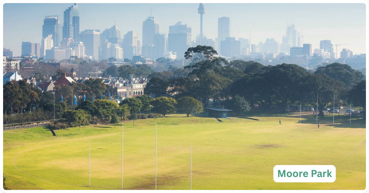
Nobody’s “living the Moore Park life” in the way you’d talk about Zetland or Redfern. What locals actually mean when they talk about Moore Park is a set of habits: a Saturday round at the golf course, a run around the SCG oval, a movie and dumplings at EQ, or a walk through to Centennial Park with the dog. It functions as shared backyard and entertainment district for the surrounding, residential suburbs, rather than a suburb in its own right.
Transport
Moore Park’s light rail stop sits on both the L2 Randwick and L3 Kingsford lines, positioned on Anzac Parade opposite Sydney Girls High School, north of Lang Road (Transport for NSW, checked August 2026). From there it’s a short run into Central and the CBD, and a similarly short hop out to Randwick or Kingsford. Buses run along Anzac Parade, Oxford Street and South Dowling Street, feeding straight into the precinct from Surry Hills, Paddington and the eastern suburbs. On event days, Transport for NSW runs extra light rail and bus services specifically for the stadium crowds, so it’s worth checking event transport arrangements before a big game rather than relying on the standard timetable. See the site’s public bus guide for wider network detail.
Healthcare
There’s no GP, pharmacy or health service based in Moore Park itself, unsurprising given there’s barely anyone living there to serve. St Vincent’s Hospital in Darlinghurst and the Prince of Wales Hospital in Randwick are both a short drive or light rail trip away, and both have emergency departments. Anyone attending an event should note that stadium first-aid is provided by venue operators on match days, separate from the general hospital network.
Schools and Childcare
There are no schools zoned to Moore Park and no childcare centres operating within its boundary. Sydney Girls High School and Sydney Boys High School both sit immediately across Moore Park Road, technically outside the suburb, and their catchments draw from the surrounding residential suburbs rather than from Moore Park itself. Families wanting proximity to this precinct for school runs are, in practice, buying or renting in Surry Hills, Paddington, Kensington or Zetland, not in Moore Park.
Industry and Work Life
Whatever employment exists in Moore Park is entirely venue and hospitality driven: stadium event staff, groundskeeping and turf management, golf course operations, EQ’s cinema and restaurant workforce, and event production crews for concerts and matches at the SCG and Allianz Stadium. It’s a workplace for a lot of casual and shift-based staff on event nights, not a place anyone commutes to for a nine-to-five desk job.
Shopping and Eating Out
The Entertainment Quarter is the destination: Hoyts and Palace cinemas, Strike bowling, Hyperkarting, Archie Brothers arcade, and a dining strip that runs from Mary’s burgers and hot pizza through to King Dynasty, Fratelli Fresh, El Camino Cantina and Winghaus sports bar. On stadium event days, expect pubs and pop-up food vendors around the SCG and Allianz Stadium precinct to do a roaring trade for a few hours either side of kick-off, then go quiet again. There is no supermarket and no everyday retail strip: for groceries or a chemist, residents of the surrounding suburbs head to Zetland’s East Village or Oxford Street in Paddington and Surry Hills.
Attractions, Parks and Natural Spaces
This is the section that actually matters for Moore Park, because the parkland is the point. The Moore Park Golf course is one of Sydney’s best-known public courses, with a 60-bay floodlit driving range alongside it. Moore Park itself flows directly into Centennial Park and Queens Park to form the broader Centennial Parklands system, managed by Greater Sydney Parklands (the operating name of the Centennial Park and Moore Park Trust), giving joggers, cyclists and dog walkers an uninterrupted green corridor stretching from the inner south-east almost to Bondi Junction.
The Sydney Cricket Ground and Allianz Stadium anchor the northern end of the precinct as Sydney’s two flagship sport venues, hosting everything from Test cricket and State of Origin to A-League finals and stadium concerts.
A separate part of the golf course, roughly 20 hectares, is currently earmarked for conversion to public green space under the Moore Park South Establishment Plan, with the change scheduled to begin after the current golf operating agreement expires in mid-2026. Under the Moore Park South Establishment Plan, around 20 hectares of the existing golf course are being converted into new public green space, alongside a reduced but retained golf offering (a minimum 9-hole course, an expanded driving range, and a short-form mini golf course). The NSW Government has committed $50 million to the project over three years.
Crime and Safety
There’s no suburb-specific crime data for Moore Park, and there couldn’t sensibly be one: with a resident population in the teens, any per-capita rate would be statistically meaningless. What exists instead is City of Sydney LGA-level data, which showed roughly 19,852 recorded incidents per 100,000 people for the year to March 2026, above the NSW average, with theft, offences against justice procedures and drug offences the three largest categories (aucrimetracker.com, sourced from BOCSAR data, checked August 2026). That LGA figure is dominated by the CBD’s density and nightlife precincts, not by Moore Park. Anecdotally, Moore Park’s own safety profile is almost entirely event-driven: large, well-managed crowds on match and concert nights, with a heavy NSW Police and venue security presence at the SCG and Allianz Stadium, and a fairly quiet, well-lit park environment the rest of the time.
Realty Market
There is no realty market to speak of. This isn’t an oversight, it’s a function of zoning and land use: Moore Park is designated parkland and special-use sporting/entertainment land, not residential land, and the 2021 Census counted just 12 private dwellings in the whole area. Domain’s own Moore Park suburb profile (checked August 2026) has no median house or unit price to display, and the handful of individual sales that do surface under this postcode (a one-bedroom unit at $607,000, a nine-bedroom home at $1,500,000) are outliers from properties that sit administratively within the postcode boundary rather than evidence of an active market. There is no rental market of any statistical size either. Anyone comparing Moore Park to a housing market on a portal is comparing it to the wrong thing: treat any “median price” you see quoted against this postcode with real scepticism, and go straight to a neighbouring suburb’s figures instead.
Our Honest Verdict
Moore Park isn’t a suburb to live in and pretending otherwise would be dishonest. It’s a postcode to know for what happens inside it: a State of Origin match, a Big Bash final, a Saturday round of golf, a movie night at EQ, or a long walk through to Centennial Park. It’s likely to appeal most to sports fans, concertgoers, golfers, joggers and cyclists who want to be near this precinct regularly, and to event organisers and hospitality operators whose business depends on match-day and event-day crowds. It is not compelling for anyone trying to buy, rent or raise a family here, because there is functionally nothing to buy or rent and no schools, childcare or GPs to build a household around.
The useful comparison isn’t another stadium precinct, it’s a real residential suburb close enough to walk or light-rail into Moore Park on event nights. Zetland is the pick: an established, unit-heavy suburb immediately to the west, with its own supermarket and everyday retail at East Village, direct light rail access, and a real, active sales and rental market to actually transact in. If what you want is Moore Park’s parkland, stadium and EQ proximity plus a front door of your own, Zetland (not Moore Park) is where you go looking.
Frequently Asked Questions
Can you actually live in Moore Park?
Almost not at all. The 2021 Census recorded just 18 residents and 12 private dwellings across the entire suburb, and there is no meaningful sales or rental market. Moore Park is zoned overwhelmingly for parkland, sport and entertainment use, not housing.
What’s the difference between Moore Park and Centennial Park?
They’re both part of the same Centennial Parklands system and managed by the same trust, but they’re separate suburbs. Centennial Park is the larger, southern parkland known for its ponds, cycling loop and equestrian tradition. Moore Park sits to its north, and is where the built infrastructure lives: the SCG, Allianz Stadium, the golf course and the Entertainment Quarter.
Is Allianz Stadium finished, and is it the same as the old Sydney Football Stadium?
Yes, it’s finished. The old Sydney Football Stadium was demolished and fully rebuilt on the same site, opening in August 2022 at a cost of $828 million (Infrastructure NSW, checked August 2026). It now seats around 42,500 and hosts rugby league, rugby union, A-League football and major concerts.
What’s the best way to get to Moore Park for a game or a movie?
Light rail is the easiest option: the L2 Randwick and L3 Kingsford lines both stop at Moore Park, a short ride from Central and the CBD. Buses run along Anzac Parade, Oxford Street and South Dowling Street. On big event days, check Transport for NSW’s event transport page, as extra services run and some roads close around the venues.
References
- Australian Bureau of Statistics, 2021 Census QuickStats, Moore Park (SAL12722), checked August 2026
- NSW Spatial Services, NSW Administrative Boundaries Theme, suburb boundary query for Moore Park, postcode 2021, checked August 2026
- Transport for NSW, “Getting to Moore Park” event transport guide, transportnsw.info, checked August 2026
- Transport for NSW, Sydney Light Rail Stop Guide, Moore Park stop, opendata.transport.nsw.gov.au, checked August 2026
- Infrastructure NSW, Sydney Football Stadium Redevelopment project page, infrastructure.nsw.gov.au, checked August 2026
- Entertainment Quarter, official site, entertainmentquarter.com.au, checked August 2026
- Moore Park Golf, official site, mooreparkgolf.com.au, checked August 2026
- Greater Sydney Parklands, Moore Park South Establishment Plan consultation, haveyoursay.nsw.gov.au, checked August 2026
- NSW Bureau of Crime Statistics and Research (BOCSAR), Recorded Crime Statistics quarterly updates, bocsar.nsw.gov.au, checked August 2026
- AU Crime Tracker, City of Sydney LGA crime statistics (BOCSAR-sourced), aucrimetracker.com/nsw/sydney-lga, checked August 2026
For a place to live near this precinct, browse the full Sydney suburbs list, or step back and explore the Sydney regions overview to see how Moore Park fits into the wider inner-city picture.