
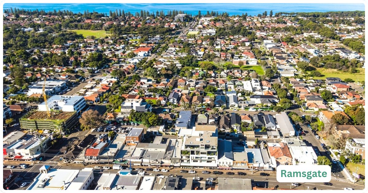
Ramsgate is the suburb that already has what its two beachside neighbours don’t: its own public school, its own Coles, and a 1920s tidal ocean pool that used to double as a zoo. It sounds like a small thing until you’ve read Kyeemagh’s and Monterey’s pages and noticed how much they lack. That self-sufficiency, on a stretch of Botany Bay foreshore with a median house price a shade over $2 million, is the whole pitch here: a genuinely liveable bayside suburb of just 1,151 people, still without a train station of its own, but with enough of the daily basics covered that the lack of one stings less.
Ramsgate Boundary and Location Map
Ramsgate sits roughly 15 kilometres south of the Sydney CBD in the Bayside Council area, fronting Botany Bay between Monterey to the north and Ramsgate Beach to the south, with Kogarah forming its inland boundary to the west. It’s easy to conflate with its near-namesake neighbour, but Ramsgate and Ramsgate Beach are two distinct gazetted suburbs sharing the same postcode (NSW Spatial Services, suburb boundary confirmed August 2026).
Quick Facts
| LGA | Bayside Council |
| Postcode | 2217 (shared with Ramsgate Beach, Kogarah and Monterey) |
| Population | 1,151 residents (2021 Census, ABS SAL13322). No reliable suburb-specific estimate has been published since |
| Growth Rate | Not separately tracked since the 2021 Census; the suburb has little vacant land, so major population shifts are unlikely outside the Ramsgate Beach apartment development next door |
| Distance from CBD | Approximately 15 km south |
| Character | Compact, multicultural, bayside suburb with its own school and supermarket, still no train station |
| Median House Price | $2,000,000-$2,050,000 (PropertyValue.com.au and Michael Kalinovski Real Estate broadly agree here, both current to mid-2026, up around 8.5% year-on-year). One source’s 36.2% annual growth figure should be ignored: it’s based on only 6 recorded sales in 12 months, a sample too small to mean anything |
| Median Unit Price | $795,000 (Michael Kalinovski Real Estate, June 2026, up 5.8% year-on-year) |
| Transport | No train station in the suburb. Nearest is Kogarah, about 2 km away (roughly a 25-minute walk), with Rockdale a further 500m at about 2.5 km (roughly 30 minutes); both are on the T4 Eastern Suburbs & Illawarra Line, about 30 minutes to the CBD. Bus routes 478 and 479 connect Ramsgate to Kogarah and Rockdale |
| Crime Rate (LGA) | Bayside LGA: violent crime 703.7 per 100,000 (ranked 97th-highest of 118 NSW LGAs, in the safer third, down from 735.4 the year before); property crime 1,315.9 per 100,000 (ranked 75th of 118, roughly mid-table, up from 1,151.3 the year before) (BOCSAR, April 2025-March 2026) |
| Childcare Availability | Adequate. At least 12 childcare centres are listed for postcode 2217, a catchment shared with Ramsgate Beach, giving real options within a short drive or walk (CareforKids.com.au, accessed August 2026) |
| School Zone Quality | Ramsgate Public School sits inside the suburb; secondary options (Kogarah High School, James Cook Boys High School, Moorefield Girls High School) are a short drive away |
| Parks & Recreation | Cook Park foreshore reserve (the same linear park system that runs from Kyeemagh to Dolls Point) and the heritage-listed Ramsgate Baths tidal pool |
| Shopping | A Coles supermarket operates on The Grand Parade; a larger replacement Coles and retail precinct is under construction just south in Ramsgate Beach |
| Health | At least two GP practices operate within the shared 2217 postcode; St George Hospital, Kogarah, is the nearest major hospital, a short drive away |
| Best For | Established families and owner-occupiers who want a self-sufficient bayside suburb (school, supermarket, historic baths) and can live without a train station on the doorstep |
What Makes Ramsgate Special
It’s Sister Suburb
The Ramsgate and Ramsgate Beach names are often used interchangeably in everyday conversation. Officially, however, they are separate suburbs, with Ramsgate centred on Rocky Point Road and Ramsgate Beach occupying the waterfront area to the east. For this profile, we’ll do just as the locals do and consider them mostly as one in terms of features, attractions, and daily life.
A Tidal Pool With a Genuinely Strange Past
Ramsgate Baths opened in 1924 as Pemberton’s Ramsgate Baths, a full aquatic centre that, for a stretch of its history, also housed a small zoo. That combination sounds implausible today, but it’s well documented local history, and the pool itself survives as a heritage-listed tidal ocean bath on the Botany Bay foreshore. It’s a genuinely useful landmark for orienting a walk along Cook Park, and one no algorithm-generated suburb page is likely to know about, let alone mention.
The Suburb That Actually Has a School and a Supermarket
Compare Ramsgate to its immediate Bayside neighbours and the difference is stark: Ramsgate Public School sits inside the suburb, and a Coles supermarket operates on The Grand Parade, neither of which Kyeemagh or Monterey can claim. It’s a genuine point of difference in a corridor where “drive somewhere else for everything” is the norm rather than the exception. The trade-off is that Ramsgate still leans on Kogarah and Rockdale for anything beyond the basics, and still has no train station of its own.
What Is It Like Living Here?
Ramsgate reads as a suburb for people who’ve already raised a family here or are doing it now: median age 47, a strong majority of owner-occupiers, and a genuinely multicultural mix (English, Australian and Greek ancestry all well represented) rather than one dominant community. It’s quieter and more settled than the description “bayside lifestyle suburb” tends to imply; the pace is closer to a small coastal town than an inner-Sydney enclave.
Transport
There is no train station in Ramsgate. Kogarah is the nearest at about 2 km (a genuine 25-minute walk), with Rockdale slightly further at about 2.5 km (roughly 30 minutes); both sit on the T4 Eastern Suburbs & Illawarra Line, with a journey to the CBD of around 30 minutes once you’re on board. Bus routes 478 and 479 run through Ramsgate to Kogarah and Rockdale, covering the gap for anyone without a car, though neither is a high-frequency service worth relying on for a tight commute. For drivers, the Princes Highway corridor via Kogarah is the main route into the city; there’s no major new road or rail project earmarked for Ramsgate itself, unlike the M6 tunnel works underway just north around Kogarah and Monterey.
Healthcare
At least two GP practices, including the Ramsgate Beach Medical Centre, operate within the shared 2217 postcode, giving residents a genuine local option rather than a forced drive. St George Hospital in Kogarah is the nearest major hospital, a short drive away, covering emergency care and the bulk of specialist services for the district.
Schools and Childcare
Ramsgate Public School sits inside the suburb (ICSEA 1039), which is a genuine advantage for local families over several of its Bayside neighbours. Secondary students head to Kogarah High School, James Cook Boys High School or Moorefield Girls High School, all a short drive rather than a walk. Childcare is workable rather than tight: at least 12 centres are listed across the shared 2217 postcode with Ramsgate Beach, giving families real choice without a long commute for daily drop-off.
Industry & Work Life
Professionals (27.5%), clerical and administrative workers (15.3%) and managers (14.0%) dominate Ramsgate’s workforce (2021 Census). Median personal weekly income sits at $779, a touch below the NSW median of $813, while median household income is a healthier $1,803 a week, reflecting the suburb’s high rate of dual-income, established households rather than young singles starting out. Proximity to the Kogarah medical, legal and education precinct is a genuine drawcard for anyone working in those fields.
Shopping & Eating Out
The existing Coles on The Grand Parade covers the day-to-day shop, and it’s about to get a genuine upgrade: a $49.7 million mixed-use development at 277 The Grand Parade in neighbouring Ramsgate Beach, approved by the Sydney Eastern City Planning Panel in February 2025, will replace the older single-storey Coles with a six-storey building housing a larger supermarket, additional retail, and 50 apartments. It sits just over the suburb boundary rather than in Ramsgate itself, but it’s the shopping precinct Ramsgate residents will actually use once it’s built. Beyond that, cafes and takeaways along The Grand Parade cover casual dining, with the fuller restaurant scene in Kogarah and Rockdale a short drive away.
Attractions, Parks and Natural Spaces
Leo Smith Reserve connects into the long stretching linear parkland providing a massive greenspace to explore, much of native bushland in places. The Tonbridge Street Reserve provides a kickabout space while most people head to the sister suburb of Ramsgate Beach for its obvious attractions.
Ramsgate Beach’s stretch of Cook Park, the same linear foreshore reserve that runs all the way from Kyeemagh to Dolls Point, got a genuine $4 million upgrade completed in early 2019: the beachfront car park was relocated back from the water to beside The Grand Parade, replaced by a widened promenade, an expanded cycleway, a new beach plaza, and new stairs and lookouts. Ramsgate Baths, the heritage-listed 1924 tidal pool, remains the standout local landmark for a swim with a sense of history attached. In November 2024, Bayside Council also completed a sand nourishment project addressing erosion along the Ramsgate and Brighton-Le-Sands foreshore, relocating over 20,000 cubic metres of sand to stabilise the beach in front of The Grand Parade for the years ahead.
Crime and Safety
No suburb-level crime data exists for Ramsgate specifically; BOCSAR reports only at the local government area level, and Bayside LGA also covers busier commercial and transit precincts that will shape the overall figures more than a small residential suburb like Ramsgate does.
For the LGA as a whole in the year to March 2026, the violent crime rate was 703.7 incidents per 100,000 people, ranking Bayside 97th-highest of 118 NSW LGAs (comfortably in the safer third of the state) and down from 735.4 the year before. Property crime sat at 1,315.9 incidents per 100,000, ranking 75th of 118 (roughly mid-table) and up from 1,151.3 the year before, a rise worth flagging rather than glossing over. There’s no suburb-specific data to confirm whether Ramsgate itself is contributing to that increase (BOCSAR, April 2025-March 2026).
Realty Market
Ramsgate’s housing market is genuinely mixed between houses and units, and unusually for this stretch of Bayside, its two main price sources broadly agree: median house price sits at $2,000,000 (PropertyValue.com.au, current to mid-2026) to $2,050,000 (Michael Kalinovski Real Estate, June 2026), both showing growth of roughly 8.5% year-on-year, with houses selling in around 25 days. Median unit price is $795,000, up 5.8% year-on-year, with units taking slightly longer at 29 days on market. One figure worth flagging and ignoring: PropertyValue.com.au also reports a 36.2% annual growth rate for houses, but that’s calculated from just 6 recorded sales in the past 12 months, a sample size too small to draw any real conclusion from, and a useful reminder of how noisy small-suburb data can get.
On the rental side, median weekly rent for houses currently sits around $990, with gross rental yield around 2.3-2.6% for houses and closer to 4% for units, meaning units are the more income-friendly option here if yield genuinely matters to you.
The Honest Verdict
Buy or rent in Ramsgate if you want a bayside suburb that actually has its own school and supermarket, a genuine sense of local history in Ramsgate Baths, and you’re comfortable with a 25 to 30-minute walk (or a short bus ride) to the nearest train station. It suits established families and owner-occupiers who plan to stay, more than first-home buyers chasing a short commute. It doesn’t suit anyone who needs walk-to-a-station convenience, or investors chasing yield over houses rather than units.
The genuine cross-shop here is Ramsgate Beach, its immediate neighbour to the east, sharing the same postcode and about to gain a significantly upgraded Coles and retail precinct. It’s busier and slightly more built-up than Ramsgate, with a stronger claim on “beach suburb” given its name, but the two are close enough in character that anyone considering one should walk the other before deciding.
Frequently Asked Questions
Are Ramsgate and Ramsgate Beach the same suburb?
No. They are two distinct gazetted NSW suburbs that share the postcode 2217 and sit next to each other along the same stretch of Botany Bay foreshore, which makes them easy to confuse in casual conversation but they are administratively separate.
Does Ramsgate have a train station?
No. The nearest is Kogarah, about 2 km away (roughly a 25-minute walk), with Rockdale a little further at about 2.5 km. Both are on the T4 Eastern Suburbs & Illawarra Line. Bus routes 478 and 479 connect Ramsgate to both stations.
What’s the median house price in Ramsgate?
Around $2,000,000 to $2,050,000 as of mid-2026, according to PropertyValue.com.au and Michael Kalinovski Real Estate respectively, both showing roughly 8.5% annual growth. Median unit price is $795,000.
What is Ramsgate Baths?
A heritage-listed tidal ocean pool on the Ramsgate foreshore, originally opened in 1924 as Pemberton’s Ramsgate Baths, a full aquatic centre that for a period also included a small zoo. It survives today as a swimming spot within the Cook Park foreshore reserve.
References
Australian Bureau of Statistics, 2021 Census Community Profile, Ramsgate (SAL13322), census date 10 August 2021, data accessed August 2026.
Bureau of Crime Statistics and Research (BOCSAR), LGA ranking for violent and property offences, April 2016 to March 2026, Bayside LGA data, local dataset accessed August 2026.
NSW Spatial Services, NSW Administrative Boundaries Theme, suburb boundary query for Ramsgate, accessed August 2026.
CareforKids.com.au, childcare service listings for postcode 2217, accessed August 2026.
Urban Digest, “$50M Mixed-Use Development Approved for Ramsgate Beach,” reporting DA-2023/370, accessed August 2026. St George and Sutherland Shire Leader, “Upgrade of Pine Park at Ramsgate close to completion,” Cook Park foreshore upgrade reporting, accessed August 2026. Bayside Council, Beach Sand Nourishment Project news release, accessed August 2026.
History Council of New South Wales, “Sydney’s Lost Aquatic Centre (and zoo!): Pemberton’s Ramsgate Baths, 1924-1970,” accessed August 2026.
For more on the area, see the complete list of Sydney suburbs by municipality and the broader Sydney regions overview.