
Woolloomooloo is the only inner Sydney suburb where a $4 pie van, a heritage-listed wool wharf lined with superyachts, and one of the highest concentrations of public housing in the state all sit within a five-minute walk of each other. That is not a marketing line, it’s the daily texture of the place. If you want a suburb that resolves that tension neatly, keep looking. If you can live comfortably next to inequality on your own doorstep and still want a harbourside postcode without the Point Piper price tag, read on.
Woolloomooloo Boundary and Location Map
Woolloomooloo sits roughly 1.5 kilometres east of the Sydney CBD, wrapped around the head of Woolloomooloo Bay on the eastern flank of the Domain. It’s a small, tightly bounded pocket: the Domain and Sydney’s eastern city fringe sit to the west, Potts Point rises up the hill to the north and east, Kings Cross and Darlinghurst border it to the south and east, and Garden Island naval base and the harbour close it off to the north. You can walk the whole suburb in about fifteen minutes, which tells you most of what you need to know about scale.
Quick Facts
| LGA | City of Sydney |
| Postcode | 2011, shared with Potts Point, Elizabeth Bay and Rushcutters Bay. This is a normal shared-postcode arrangement across this part of inner eastern Sydney, not an anomaly. |
| Population | 3,792 at the 2021 Census (ABS, SAL14424). Domain’s current estimate puts it at roughly 4,000 as of mid-2026, a modest lift consistent with a suburb that has almost no vacant land left to build on. |
| Growth Rate | Slow and shallow, around 6% since the 2021 Census. Heritage protection over most of the housing stock and a near-total absence of developable sites cap how much this can ever grow. The next Census, in August 2026, should sharpen this figure. |
| Distance from CBD | Approximately 1.5-2 kilometres east of the Sydney CBD |
| Character | A dense, low-rise waterfront pocket that runs from public housing towers to $1,000-a-night hotel suites within a few streets, with a working-harbour history still visible in the terraces and the wharf |
| Median House Price | $2.3 million over the past 12 months (propertyvalue.com.au, 2026), but treat this cautiously: only around 11 sales were recorded in that period, and Woolloomooloo’s dwelling stock is 0.5% separate houses (ABS 2021 Census), so this figure effectively describes terrace and semi sales, not detached houses. Too thin a sample to call a reliable trend on its own. |
| Median Unit Price | $830,000 for a 1-bedroom unit and $1.6 million for a 2-bedroom unit over the past 12 months (Domain, 2026) |
| Transport | Kings Cross station (T4 Eastern Suburbs & Illawarra Line) is the nearest heavy rail, an uphill 10-15 minute walk from the Finger Wharf end of the suburb. Frequent bus routes run along Cowper Wharf Road and up William Street into the city. |
| Crime Rate (LGA) | 19,852 recorded incidents per 100,000 people across the City of Sydney LGA for the year to March 2026 (BOCSAR-sourced data via AU Crime Tracker), above the NSW average, driven mainly by theft. This is an LGA-wide figure covering the entire City of Sydney council area, not a Woolloomooloo-specific rate, and no suburb-level BOCSAR breakdown exists. |
| Childcare Availability | Tight. One dedicated long day care centre (SDN Woolloomooloo) operates inside the suburb itself, with a handful of additional options a short walk away in Potts Point and Kings Cross. Realistic for one child on a plan-ahead basis, not a suburb to assume you’ll get a same-year place. |
| School Zone Quality | Plunkett Street Public School is the local zoned primary; no zoned local high school inside the suburb itself, families typically zone into nearby high schools or look at selective/independent options |
| Parks & Recreation | The Domain (immediately adjacent), Andrew “Boy” Charlton Pool on the harbour edge, and Beare Park a short walk away in Elizabeth Bay |
| Shopping | No shopping centre. Harry’s Cafe de Wheels and the Woolloomooloo Wharf dining strip cover eating out; day-to-day grocery shopping means a walk up to Potts Point or Kings Cross |
| Health | Local GPs are mostly in adjoining Potts Point and Kings Cross; St Vincent’s Hospital, Darlinghurst is the nearest major public hospital, a 10-15 minute walk or short bus ride away |
| Best For | High-income professionals and downsizers who want harbour position without a harbourfront mansion budget, and who are comfortable living alongside a large, long-established public housing community |
What Makes Woolloomooloo Special
From Frog Hollow to the Finger Wharf: a Working History
Long before real estate agents got hold of it, this stretch of harbour was known as Cockle Bay and Frog Hollow, and Governor Phillip had actually marked it out as a reserve for Aboriginal people. The Gadigal name was Walla-Mulla, meaning “young kangaroo”, after the rare black kangaroo that once haunted the area, and the name settled into something close to its current spelling by the 1830s (Francis Pollon, “The Book of Sydney Suburbs,” 1988). In 1793 the colony’s commissary, John Palmer, was granted 100 acres at Garden Island Cove and called it Woolamola Farm, which is where the suburb’s name actually comes from. Palmer sold up in 1822 and the land passed through several hands before being carved up.
The 1830s land grants to figures like Judge James Dowling and Edward Deas Thompson are why you still walk down Dowling, Judge, Forbes and Bourke Streets today, and a handful of the terraces from that era, restored between Brougham and Bourke Streets, are still standing. Plunkett Street takes its name from John Hubert Plunkett, a one-time attorney-general, and gave its name to the local public school, which later moved to its current site on Forbes Street. By the 1880s the suburb had turned firmly towards wharves, fish markets and the industries that go with a working waterfront, and it stayed a blue-collar, dockside suburb for most of the twentieth century.
Then came the 1960s and 1970s, when large tracts were resumed for the construction of the Eastern Suburbs Railway and city freeways, hollowing the suburb out. Pollon’s 1988 account describes the state’s Department of Housing and Construction as “energetically buying” property at the time “to provide proper homes for low-income families”, framing it as a suburb still mid-transition. That transition is long finished. The public housing build-out that Pollon described as underway in the late 1980s was substantially completed decades ago, and it left a legacy that still defines the suburb today: roughly a fifth of Woolloomooloo residents rent from a housing authority, a rate around ten times higher than neighbouring Potts Point or Darlinghurst.
The Finger Wharf and the Two Woolloomooloos
Pollon’s 1988 entry doesn’t mention it by name (the wharf’s conversion hadn’t happened yet), but no honest commentary on Woolloomooloo can skip the Finger Wharf. Built by the Sydney Harbour Trust in 1911-1915, it was once described as the largest timber-piled wharf in the world, and it operated as a working wharf until it closed in the 1970s. A major conservation and adaptive-reuse project between 1998 and 2000 converted the heritage-listed structure into apartments at the northern end and a hotel and restaurant strip at the southern end. As of 2026 that’s still exactly what it is, and the Ovolo Woolloomooloo hotel anchors the south end, apartments line the rest, and a run of restaurants and bars trade along the boardwalk, all sitting on piers directly over the water.
Pollon also notes that the old Domain Baths, established in 1908 on Woolloomooloo Bay, had “now” (in 1988) been rebuilt to olympic standard and renamed after Andrew “Boy” Charlton, the Australian Olympic swimmer. That’s still true and still current, and the Andrew (Boy) Charlton Pool remains an operating 50-metre outdoor pool run by City of Sydney Leisure (managed by Belgravia Leisure), open daily through the warmer months and closing for its usual winter break, as it always has.
What makes Woolloomooloo distinctive, though, isn’t any single landmark. It’s the juxtaposition. Walk from the Finger Wharf’s apartments (where a two-bedroom unit runs into seven figures) up Cathedral Street or Dowling Street and you’re inside one of the largest concentrations of public and social housing in inner Sydney, much of it in mid-century walk-up blocks that have housed the same families and communities for generations. This isn’t a suburb quietly gentrifying its housing commission stock out of existence, at least not yet: the two communities exist side by side, visibly, every day.
What Is It Like Living Here?
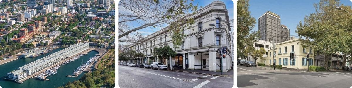
Ask anyone who actually lives in Woolloomooloo and the same three things come up: the walk to the city is short, the noise from the Wharf strip and nearby Kings Cross carries further than you’d expect on a Friday night, and parking your own car is close to a lost cause. It suits people who have made peace with apartment living, don’t need a backyard, and get real value out of being able to walk to work in the CBD in fifteen minutes flat.
Transport
Kings Cross station, on the T4 Eastern Suburbs & Illawarra Line, is the nearest heavy rail option, but it sits up the hill and it’s a 10-15 minute walk from the Finger Wharf end of the suburb, longer if you’re carrying shopping. From Kings Cross it’s about 5 minutes into Martin Place.
There is no Sydney Metro station inside Woolloomooloo itself and none planned for the suburb; the nearest metro access is at Martin Place or Barangaroo in the CBD, which for most residents means catching a bus or the train in first rather than walking directly to a metro platform.
Bus routes along Cowper Wharf Road and up William Street connect the suburb directly into the city and out to Bondi Junction, and are the more convenient option for anyone living down near the water.
The Eastern Distributor tunnel runs beneath the western edge of the suburb, carrying M1 traffic between the city and the airport, but it’s a through-route: it doesn’t add an on/off ramp for local Woolloomooloo traffic. Owning a car here means accepting expensive, scarce street parking; most residents who need one use car share or simply don’t own one.
Healthcare
Woolloomooloo itself has no major medical centre. GPs are a short walk away in Potts Point and Kings Cross, and St Vincent’s Hospital, Darlinghurst is the nearest major public hospital, roughly 10-15 minutes on foot or a quick bus trip. St Vincent’s also runs specialist and homeless health outreach services relevant to a suburb with this much public housing and a visible rough-sleeping population around the Domain end. There’s no dedicated aged care facility inside the suburb; the closest options sit in Potts Point and Darlinghurst.
Schools and Childcare
Plunkett Street Public School is the zoned local primary, tracing its name and site history back to the 1860s (the current Forbes Street building replaced the original Plunkett Street site). There is no zoned local high school inside Woolloomooloo; families typically zone into a nearby comprehensive high school or pursue a selective or independent placement elsewhere in the inner city. Given the suburb’s demographic skew (median age 39, only 4.2% of the wider Potts Point-Woolloomooloo area aged 0-14 as of the 2021 Census), this isn’t a suburb built around family life, and the school infrastructure reflects that.
Childcare is tight: SDN Woolloomooloo is the one dedicated long day care centre operating inside the suburb, and beyond that families are drawing on a handful of centres a short walk away in Potts Point and Kings Cross. Plan ahead if you need a place; this is not a suburb with spare childcare capacity sitting idle.
Industry & Work Life
Most working residents commute a short distance into the CBD, and a high proportion do it on foot rather than by any form of transport at all, a real point of difference from almost anywhere else in Sydney. Locally, hospitality and tourism (the Wharf’s hotel, restaurants and bars) provide a meaningful chunk of employment, and Garden Island naval base, adjoining the suburb to the north, is a significant direct and indirect employer. Beyond that, there’s very little local industry left; Woolloomooloo today is overwhelmingly a place people live and sleep in a workforce housed elsewhere, not a place people work locally in large numbers outside hospitality and defence.
Shopping & Eating Out
There’s no shopping centre and no full-line supermarket in Woolloomooloo; day-to-day groceries mean a walk up to Potts Point or Kings Cross. What the suburb has instead is famous eating and drinking.
Harry’s Cafe de Wheels, on Cowper Wharf Road since 1945, is still trading in 2026 and is still one of Sydney’s most photographed pie carts, a real piece of continuity in a suburb that has changed around it dramatically.
The Woolloomooloo Wharf dining strip runs the length of the Finger Wharf, with the Ovolo Hotel’s bars and restaurants anchoring the southern end and a rotating cast of upmarket seafood and Italian venues filling out the rest, all with water views most Sydney diners would pay a premium for and, at the Wharf, generally do.
Attractions, Parks and Natural Spaces
The Domain sits directly on the suburb’s western boundary, giving Woolloomooloo residents effectively unlimited green space on foot, including access to the Art Gallery of NSW and the Royal Botanic Garden beyond it.
The Andrew (Boy) Charlton Pool, a 50-metre outdoor pool on the harbour’s edge, is open daily through summer and autumn before closing for its usual winter break, and remains one of Sydney’s better harbourside lap-swimming options.
Beare Park, a short walk away in neighbouring Elizabeth Bay, adds harbourfront green space and a small beach-style foreshore for anyone wanting a change of scenery. The Finger Wharf itself is as much an attraction as a dining precinct, and worth the walk even if you’re not eating there.
Crime and Safety
The City of Sydney LGA recorded 19,852 incidents per 100,000 people for the year to March 2026, above the NSW state average, with theft the largest single category. This is an LGA-wide figure covering the entire City of Sydney council area, from Woolloomooloo through the CBD, Kings Cross and Redfern, and there is no BOCSAR data broken down to Woolloomooloo specifically, so don’t read it as a suburb-level rate. Anecdotally, locals and forum discussion point to petty theft and late-night antisocial behaviour around the Kings Cross fringe and the Domain’s Art Gallery Road side as the more visible day-to-day issues, rather than serious violent crime; that’s anecdotal signal, not a substitute for the LGA data above.
Realty Market
Woolloomooloo’s housing stock is about as far from a typical Sydney suburb as it gets: 72.8% flats and apartments, 26.1% semi-detached and terrace housing, and just 0.5% separate houses, according to the 2021 Census (ABS, SAL14424). Anyone searching “median house price” for this suburb is really looking at terrace and semi sales, because there’s practically nothing else to sell. Over the past 12 months to mid-2026, that figure sat around $2.3 million (propertyvalue.com.au), up sharply year-on-year, but on only around 11 recorded sales, which is too thin a sample to treat as a reliable trend rather than a snapshot of whatever happened to sell.
Unit prices are more statistically solid given the volume of apartment stock: a 1-bedroom unit has traded around $830,000 and a 2-bedroom unit around $1.6 million over the past 12 months (Domain, 2026). Both figures put Woolloomooloo firmly in premium inner-city territory, on par with or above much of Potts Point, largely on the strength of the Finger Wharf’s waterfront apartments pulling the average up.
The rental market tells the more complete story of who actually lives here day to day: 70.6% of Woolloomooloo households rent (ABS, 2021 Census), against a combined owned-outright and mortgaged share of just 27%. Median weekly rent at the 2021 Census sat at $500, and current listing samples in 2026 run from roughly $795 to $850 a week for one-bedroom units, reflecting several years of rental growth since. Single-person households dominate (77% of all households, per Domain’s current data), which lines up with a suburb built almost entirely around one- and two-bedroom stock rather than family-sized housing.
Our Honest Verdict
Woolloomooloo works for a narrow but slice of buyers and renters. High-income professionals and downsizers who want a real inner-harbour address, are happy in a one or two-bedroom apartment, and place a premium on being able to walk to the CBD, the Domain and a excellent waterfront dining strip. It does not suit families needing space, a backyard, or a strong local school pipeline; the housing stock and the school zoning simply aren’t built for that life. It is less compelling for investors chasing yield, given how far unit and terrace prices have run relative to achievable rents.
Woolloomooloo’s less obvious trade-off is its unusual social mix. Public and social housing sits alongside expensive private apartments and waterfront properties, making the contrast between different parts of Sydney’s housing market unusually visible in everyday life. For some residents, that diversity is part of what makes Woolloomooloo distinctive; for others, the area’s density, traffic, noise and less polished streetscape can be a drawback. It’s one of those suburbs where a visit during the day tells only part of the story, so prospective buyers should spend some time walking around the area at different times before deciding whether the character suits them.
The most suburb to cross-shop against Woolloomooloo is Potts Point. It shares the same postcode and effectively the same border, has a comparable apartment-heavy housing stock and walk-to-city convenience, but without the same scale of public housing presence and generally at a higher entry price for equivalent apartment stock. If the water frontage and the Wharf dining strip are the drawcard, Woolloomooloo gets you there for less. If you’d rather skip the juxtaposition altogether, Potts Point is the more conventional choice at a similar walk-to-CBD distance.
Frequently Asked Questions
Is Woolloomooloo a safe suburb to live in?
The City of Sydney LGA, which includes Woolloomooloo, recorded a crime rate above the NSW average for the year to March 2026 (19,852 incidents per 100,000 people), driven mostly by theft. That’s an LGA-wide figure, not a Woolloomooloo-specific one, and it covers a much larger and busier area including the CBD and Kings Cross. Most residents describe day-to-day safety as reasonable, with petty theft and late-night noise as the more common issues rather than serious crime, but there’s no suburb-level data to confirm that beyond anecdote.
Can I get a train from Woolloomooloo into the city?
Yes, via Kings Cross station on the T4 Eastern Suburbs & Illawarra Line, though it’s a uphill 10-15 minute walk from most of the suburb, not a five-minute stroll. Many residents find the bus routes along Cowper Wharf Road and William Street more convenient for a direct trip into the CBD.
Is Woolloomooloo a good suburb for families with kids?
Not really, and it isn’t built to be. There’s no zoned local high school, childcare capacity is tight, and the housing stock is almost entirely one and two-bedroom apartments and terraces. Families who do live here tend to be smaller households or are consciously trading space for a walk-to-city, harbour-adjacent lifestyle.
What is the Woolloomooloo Finger Wharf and can the public visit?
The Finger Wharf is a heritage-listed former wool store wharf, built 1911-1915, now home to apartments, the Ovolo Woolloomooloo hotel, and a strip of restaurants and bars on piers over the water. It’s fully open to the public for walking, dining and drinking, and it’s one of the suburb’s drawcards for visitors as well as residents.
Why does Woolloomooloo have so much public housing?
Woolloomooloo was a poor, working-class dockside suburb through most of the twentieth century, and large parts of it were compulsorily resumed in the 1960s and 1970s for the Eastern Suburbs Railway and city freeways. The state government subsequently bought and built extensively through the area to house low-income residents, a process that Pollon’s 1988 account describes as still actively underway at the time. That build-out is long complete, and today around a fifth of residents rent from a housing authority, roughly ten times the rate in neighbouring Potts Point or Darlinghurst, making it one of the most mixed-income pockets of inner Sydney.
References
- Francis Pollon, “The Book of Sydney Suburbs,” Angus & Robertson, 1988, entry on Woolloomooloo
- Australian Bureau of Statistics, 2021 Census QuickStats, Woolloomooloo (SAL14424), accessed August 2026
- Australian Bureau of Statistics, 2021 Census QuickStats, Potts Point – Woolloomooloo (SA2), accessed August 2026
- Domain, Woolloomooloo NSW 2011 Suburb Profile, accessed August 2026
- PropertyValue.com.au, Woolloomooloo NSW 2011 property data, accessed August 2026
- NSW Bureau of Crime Statistics and Research, NSW Recorded Crime Report, March 2026 Quarter, and AU Crime Tracker LGA data derived from BOCSAR figures, City of Sydney LGA, year to March 2026
- City of Sydney Leisure, Andrew (Boy) Charlton Pool operating information, accessed August 2026
- NSW Spatial Services, NSW Administrative Boundaries Theme, Woolloomooloo suburb boundary and postcode data, queried August 2026
- SDN Children’s Services and StartingBlocks.gov.au, SDN Woolloomooloo Children’s Education and Care Centre listing, accessed August 2026
- NSW Department of Education, Plunkett Street Public School, accessed August 2026
- Coppo Associates, Woolloomooloo Finger Wharf heritage and conservation project history, accessed August 2026
For more Sydney suburb profiles, browse the full Sydney suburbs list, or explore the broader Sydney regions overview.