
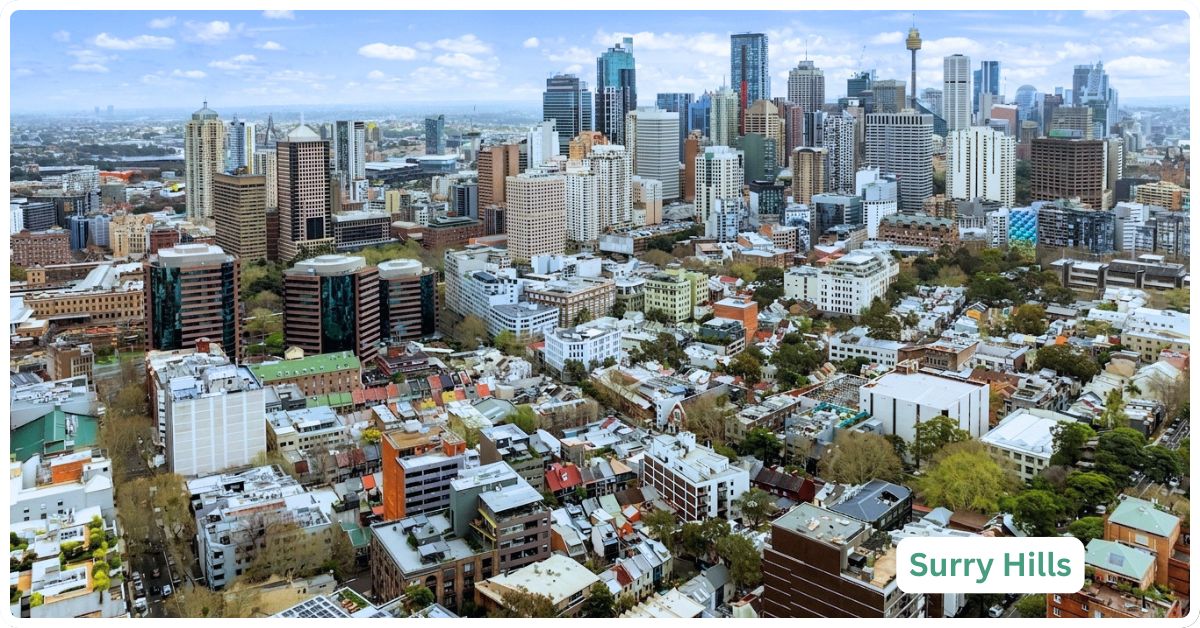
Surry Hills asks a genuine trade-off of anyone thinking about living here: you get the best café strip walk in inner Sydney, a five-minute stroll to Central Station, and terrace streets that photograph beautifully, but you give up space, quiet and off-street parking almost entirely. This is a suburb built for people who want to walk to everything and don’t mind paying apartment-sized money for a terrace-sized life. If that’s not the trade-off you’re after, the postcode next door might suit you better.
Surry Hills Boundary and Location Map
Surry Hills sits roughly two kilometres south of the Sydney CBD, wrapped almost entirely by Central Station and the inner-city ring road system. It borders Redfern and Chippendale to the west and southwest across the rail corridor, Darlinghurst to the north and northeast along Oxford and Riley Streets, Moore Park and Paddington to the east beyond South Dowling Street, and Redfern and Waterloo to the south around Cleveland and Elizabeth Streets. It’s a small, dense, almost entirely landlocked suburb, no waterfront, no bushland edge, just streets of terraces packed in around a spine of light industry turned café strip.
Quick Facts
| LGA | City of Sydney |
| Postcode | 2010 |
| Population | 17,184 (SA2 estimate, May 2026, up from 15,828 at the 2021 Census) |
| Growth Rate | +8.6% since the 2021 Census, driven almost entirely by overseas migration (areasearch.com.au, May 2026 estimate) |
| Distance from CBD | Approximately 2km south of the Sydney CBD |
| Character | Dense inner-city terrace suburb, cafe/creative strip, heavily renter-occupied |
| Median House Price | $2.32m-$2.5m (CoreLogic/PropTrack, as reported May 2026) |
| Median Unit Price | $885,000-$940,000 (as reported May 2026) |
| Transport | Central Station on foot (T1, T2, T3, T4, T8 lines and intercity/regional services), L2/L3 CBD and South East Light Rail through the suburb, multiple bus routes |
| Crime Rate (LGA) | City of Sydney LGA recorded 19,852 incidents per 100,000 people for the year to March 2026 (BOCSAR data), above the NSW average. LGA-wide figures are heavily skewed by the CBD and nightlife precincts, not suburb-specific; see Crime and Safety below |
| Childcare Availability | Adequate. Several ACECQA-registered long day care and preschool services within the suburb, though inner-city waitlists are common |
| School Zone Quality | Bourke Street Public School is the local zoned primary; no zoned government high school sits within Surry Hills itself, families typically zone into nearby options or choose selective/private |
| Parks & Recreation | Prince Alfred Park, Ward Park, Shannon Reserve, with Moore Park and the Sydney Cricket Ground precinct a short walk east |
| Shopping | Crown Street strip (cafes, boutiques, design stores), plus Devonshire Street and Elizabeth Street pockets |
| Health | Multiple local GP clinics (Crown Street Medical Centre, Surry Hills Doctors); St Vincent’s Hospital, Darlinghurst, is the nearest major public hospital |
| Best For | Young professionals, creatives and dual-income-no-kids couples who want to walk everywhere and don’t need a backyard |
What Makes Surry Hills Special
From Sheep Quarantine Ground to Café Strip: The History
Surry Hills was probably named after the Surrey Hills in England, an area known for its rural beauty, though it’s genuinely hard to picture today’s Surry Hills as either beautiful or agricultural (Francis Pollon, “The Book of Sydney Suburbs,” 1988). It began as exactly that, though: a farm. Major Joseph Foveaux (1765-1846), a soldier and administrator of the early colony, held the land from around 1811 as Surry Hills Farm, and Foveaux Street still carries his name today. The property changed hands in 1822, sold to James Underwood (1776?-1844), a merchant, distiller and shipbuilder, and was leased out to various occupants until it was sold again in 1878-79. In the first half of the nineteenth century, John Terry Hughes built the Albion Brewery on a site later occupied by Tooheys Brewery, with his nephew J. T. Hughes and his wife living next door at Albion House. None of this brewing or farming activity survives on the ground today; it’s purely a matter of record.
In 1832, an area south of the railway line was set aside as a Sheep Quarantine Ground, a buffer to stop scab-infected sheep being driven along public roads. That land was subdivided and sold in 1885, well over a century ago, and nothing of the quarantine function remains, it’s now ordinary suburban streetscape. A post office serving the area opened in 1882, and a local school followed in April 1883. By 1879 the railway station was already running, and the suburb, with its neat Victorian homes and spired churches, grew quickly on the back of that access. Rapid development followed the 1878-79 sale of the Underwood estate, reshaping what had been farmland into the tight terrace grid that still defines Surry Hills today.
The suburb had a real air of elegance through the Victorian era, with several grand houses built in the style carried over from the earlier Macquarie period. Durham Hall is the standout example: George Hill bought the site from Thomas Broughton and built the mansion in 1835. The Hill family had made its money more prosaically, William Hill ran a timberyard in George Street, oversaw several slaughterhouses, and owned city inns, and in the 1830s his sons ran their own hotels (the Butchers Arms, the Carpenters Arms and the Wheelwrights Arms, all on Pitt Street, plus the William the Fourth Inn on Sussex Street, run by son David). Durham Hall stood in its original state as late as 1946, but that ownership era ended in 1957 when the Commonwealth Trading Bank of Australia bought the site and house.
Central Station, Strawberry Hills and the Making of a Working Suburb
The Devonshire Street cemetery, where many early colonial settlers were buried, once occupied part of this area. When the decision was made to make Central the Sydney terminus, the cemetery was relocated elsewhere entirely, and Central Railway Station opened on the site on 4 August 1906, meaning the cemetery itself is long gone from Surry Hills and exists today only in historical record. That opening reshaped the tram network, with trams and horse-drawn traffic rerouted along George Street past the new Anthony Hordern Palace Emporium, built after a disastrous 1901 fire had destroyed the previous Hordern store and killed four employees. For decades afterward, this southern edge of the city was Sydney’s main shopping district, precisely because Central Station made it reachable from anywhere in the state; that retail dominance has since shifted well north into the CBD proper, and the old Hordern Emporium building no longer functions as the department store it once was.
A smaller pocket around Cleveland and Elizabeth Streets was historically known as Strawberry Hills, complete with its own Strawberry Hills post office on that corner, a name that survives today only in the address of the corner of Chalmers and Cleveland Streets. From the 1850s onward, Surry Hills filled in with terrace houses and workers’ cottages and became a genuinely working-class suburb, with local jobs concentrated in light industry, particularly clothing manufacture. It was also a landing spot for families arriving in Australia after the Second World War, when property here was cheap and the location convenient. Writing in 1988, Francis Pollon described a suburb that was, by then, already multicultural, with a large Lebanese community joining older immigrant families, and old terraces starting to be restored as middle-class buyers moved in for the inner-city lifestyle. That gentrification wave was only just getting started when Pollon wrote it up.
Nearly forty years on, Surry Hills has run a long way further down that same curve: the light industry and clothing factories have almost entirely given way to the creative, media, tech and hospitality economy the suburb is known for today, and the median house price (well over $2 million as of 2026, see the Realty Market section below) reflects a suburb that finished its gentrification story some time ago rather than one still mid-transition.
The Crown Street Strip
What actually sets Surry Hills apart from most other inner-city Sydney suburbs isn’t its history, it’s Crown Street itself, a genuinely walkable strip of cafes, small-batch restaurants, design and homewares stores and independent boutiques that runs the length of the suburb. It’s less polished than Paddington’s Oxford Street and less party-driven than Kings Cross; it reads more like a suburb that grew its own dining and retail scene organically out of the terrace population that already lived there, rather than one built for tourists. Pair that with the suburb’s dense concentration of creative agencies, media companies and tech start-ups (a real point of difference from most residential inner-city suburbs, which are almost purely residential) and you get a place that functions as a live-work suburb for a specific kind of resident far more than most of Sydney’s inner ring.
What Is It Like Living Here?
Living in Surry Hills day to day means small terrace rooms, narrow streets, limited parking and constant noise from Crown Street on a Friday night, in exchange for being able to walk to Central Station, a decent bar, and a genuinely good coffee within about five minutes of your front door. It suits people who’ve made peace with paying a premium for location over square metres, and it doesn’t suit anyone who needs a driveway, a backyard for kids, or true quiet after 10pm on weekends.
Transport
This is where Surry Hills genuinely earns its price tag. Central Station sits right on the suburb’s northwestern edge, giving residents walking access to the T1 North Shore & Western Line, T2 Leppington & Inner West Line, T3 Liverpool & Inner West Line, T4 Eastern Suburbs & Illawarra Line and T8 Airport & South Line, plus intercity and regional NSW TrainLink services, all from the one hub. The CBD and South East Light Rail (L2 Randwick and L3 Kingsford lines) runs directly through Surry Hills between Central and Moore Park, having opened in December 2019 and April 2020 respectively; both lines are now fully operational with services roughly every four minutes during weekday peaks.
A network of City of Sydney and Transport for NSW bus routes covers Cleveland Street, Elizabeth Street, Oxford Street and Crown Street, giving useful east-west and north-south links that don’t rely on the train at all.
The genuine trade-off is car access: streets are narrow, one-way, and largely resident-permit or paid parking, so this suburb rewards people happy to walk, cycle or use transit rather than drive.
Healthcare
Surry Hills is well served for everyday GP care, with clinics including Crown Street Medical Centre and Surry Hills Doctors operating within the suburb. For anything more serious, St Vincent’s Hospital, a major public hospital, sits just across the boundary in neighbouring Darlinghurst, a genuinely short trip by foot, bus or light rail rather than a suburb that leaves residents without a nearby emergency department. St Vincent’s Private Hospital and the St Vincent’s Clinic specialist rooms are on the same campus for those with private cover.
Schools and Childcare
Bourke Street Public School is the local zoned government primary, serving a suburb where school-age children are genuinely rare (2021 Census data shows the population skewing heavily toward 20s and 30s, with a median age of 35 and children underrepresented compared to the NSW average). There’s no zoned government high school sitting inside Surry Hills itself, families with older children typically look to nearby zoned options in adjoining suburbs, or opt for one of the selective or independent schools accessible from the inner city.
On childcare, the suburb has a reasonable spread of ACECQA-registered long day care and preschool services, including SDN Surry Hills Children’s Education and Care Centre, Surry Hills Neighbourhood Centre Long Day Care, Surry Hills Montessori Childcare and Preschool, Surry Hills Early Learning Centre, and an Only About Children service. That’s a genuinely useful number of options for a suburb this size, but inner-city long day care demand across Sydney routinely outstrips supply, so waitlists at the more established centres are common and families are well advised to enquire early rather than assume a place will be available on short notice.
Industry & Work Life
Surry Hills has shifted a long way from its clothing-industry, working-class roots. Today it’s one of the more genuine live-work suburbs in inner Sydney, home to a dense cluster of creative agencies, design studios, digital marketing firms and tech start-ups, many operating out of converted warehouse and terrace office space rather than purpose-built towers. A lot of residents work locally or a short commute away in the CBD, which is part of why the suburb has such a strong daytime café culture on weekdays, not just weekends. It’s a suburb that suits people whose work and social life both happen within a few kilometres of home, rather than commuters heading out to business parks in the west or north.
Shopping & Eating Out
Crown Street is the spine of Surry Hills life: a long run of cafes, restaurants, wine bars, homewares and design stores, and independent fashion boutiques that locals actually use day to day rather than a strip built purely for visitors.
Devonshire Street adds a well-known food lane running toward Central, and pockets of Elizabeth Street and Foveaux Street carry their own smaller cluster of eateries and specialty stores.
For bigger-format shopping, residents lean on the CBD (a short walk or one light rail stop away) rather than any large shopping centre within Surry Hills itself, there isn’t one, and that’s a genuine trade-off for anyone used to a Westfield-style one-stop shop.
Attractions, Parks and Natural Spaces
Surry Hills isn’t a green suburb by Sydney standards, terrace density leaves little room for large open space, but what it has is well used. Prince Alfred Park, on the suburb’s northern edge near Central, combines an outdoor pool, playing fields and open lawn and is one of the busiest inner-city green spaces in Sydney. Ward Park and Shannon Reserve are smaller neighbourhood parks, the latter on Crown Street hosting a naturally shaded playground and a monthly community market on the first Saturday. For anything larger, Moore Park and the Sydney Cricket Ground and Allianz Stadium precinct sit just across the eastern boundary, reachable on foot or via the light rail, giving residents access to genuine sporting and event infrastructure without it being inside the suburb itself.
Crime and Safety
Crime statistics for Surry Hills specifically don’t exist as a standalone figure; BOCSAR (the NSW Bureau of Crime Statistics and Research) reports at the local government area level, which for Surry Hills means the whole City of Sydney LGA, an area that also includes the CBD, Kings Cross-adjacent nightlife precincts and Redfern. The City of Sydney LGA recorded 19,852 incidents per 100,000 people for the year to March 2026 (BOCSAR data), above the NSW average, driven heavily by theft and offences concentrated around the CBD and licensed-venue precincts rather than by residential streets like Surry Hills’ terrace rows. That LGA-wide figure is worth reading with real caution before applying it directly to Surry Hills for exactly that reason. Residents and prospective buyers wanting a more granular, current read should check BOCSAR’s crime mapping tool directly, which can filter closer to suburb level than the headline LGA figure allows.
Realty Market
Surry Hills’ housing stock is overwhelmingly high-density: 2021 Census figures put flats and apartments at 68.5% of dwellings and semi-detached terraces at a further 29.1%, with genuinely detached houses making up barely 1% of the suburb. As of May 2026, CoreLogic and PropTrack estimates put the median house price (mostly meaning terraces, given how little detached stock exists) somewhere between $2.32 million and $2.5 million, up somewhere in the order of 8-15% over the previous 12 months depending on the data source, a genuinely strong run for an already expensive suburb. Units have told a different story over the same period, with CoreLogic-reported movement described as flat to slightly negative annually, suggesting the apartment segment hasn’t kept pace with the terrace and house market.
Median unit prices as of May 2026 sit around $885,000-$940,000. Rental demand remains strong, unsurprising given 65.4% of Surry Hills dwellings were renter-occupied at the 2021 Census, easily the dominant tenure type in the suburb. Median weekly asking rent for units was reported around $775-$800 as of May 2026, putting gross rental yield at roughly 4.4%, a reasonable yield by inner-Sydney standards though not a figure that should be read as investment advice; it is less compelling for investors chasing high yield specifically, given the high entry price required to buy in.
Our Honest Verdict
Surry Hills is likely to appeal most to young professionals, creatives and dual-income couples without kids who want to walk to work, walk to dinner, and walk to the train, and who are comfortable paying a premium in dollars and square metres for that convenience. It does not suit anyone who needs a backyard, off-street parking, or genuine quiet on a Friday or Saturday night, Crown Street is a lively strip and it stays that way well into the evening. Families with school-age children will find the lack of a zoned high school within the suburb, and the near-total absence of detached houses, a real limitation.
The genuine cross-shop suburb here is Darlinghurst, its northern neighbour, which offers a similar inner-city terrace lifestyle, comparable walkability to the CBD, and its own strong dining and nightlife scene, worth comparing directly against Surry Hills for anyone weighing up this part of the inner city, rather than treating Surry Hills as a one-suburb decision. Someone chasing a slightly quieter, more residential inner-city feel without giving up much walkability might find Darlinghurst worth a look side by side with Surry Hills, though the two are close enough in character that the decision often comes down to which specific street and price point is available at the time.
Frequently Asked Questions
Is Surry Hills a good suburb for families with young children?
It can work for families with very young children, given the local childcare options and Prince Alfred Park’s playground and open space, but the near-total absence of detached housing, the lack of a zoned government high school within the suburb, and 2021 Census data showing children genuinely underrepresented in the population all point toward Surry Hills being better suited to pre-school-age families than to those with children moving through primary and high school.
How far is Surry Hills from Sydney’s CBD?
Around 2 kilometres. Central Station sits right on the suburb’s edge, and the CBD and South East Light Rail runs directly through the suburb toward Circular Quay, so the practical travel time into the city centre is genuinely short, often faster on foot or light rail than by car given inner-city traffic and limited parking.
Why is there no median house price for a “typical” detached house in Surry Hills?
Because there’s almost no detached housing stock left to price. Census data shows separate houses make up roughly 1% of dwellings in the suburb; what the market calls “houses” here are overwhelmingly Victorian-era terraces, which is what the reported $2.32 million-$2.5 million median house price figure (as of May 2026) actually reflects.
Is Surry Hills safe?
There’s no suburb-specific crime figure for Surry Hills; BOCSAR data is reported at the City of Sydney LGA level, which also captures CBD and nightlife-precinct crime that isn’t representative of residential Surry Hills streets. Inner-city LGAs of this kind typically run above the NSW average on theft and public-place offences, largely concentrated around licensed venues and the CBD rather than the terrace streets themselves. Anyone wanting a precise, current figure should check BOCSAR’s crime mapping tool directly.
What’s the Lebanese community connection people mention about Surry Hills?
Historically, Surry Hills became home to a significant Lebanese community in the postwar decades, part of a broader wave of migrant families drawn to the suburb’s cheap terrace housing and light-industry jobs (Pollon, 1988). The suburb’s population and character have shifted substantially since then through gentrification, and 2021 Census ancestry data now shows English, Australian, Irish and Chinese ancestries as the largest groups, so while that Lebanese community history is a genuine part of the suburb’s story, it’s a smaller share of the current population than the historical association might suggest.
References
- Francis Pollon, “The Book of Sydney Suburbs,” Angus & Robertson, 1988, entry on Surry Hills
- Australian Bureau of Statistics, 2021 Census QuickStats, Surry Hills (SAL13714), accessed 2026
- AreaSearch, Surry Hills SA2 117031336 population estimate, May 2026
- Murray Property, Surry Hills Property Market Update 2026, published May 2026
- Transport for NSW, CBD and South East Light Rail project page, accessed 2026
- NSW Spatial Services, boundary and administrative area query, City of Sydney LGA, accessed 2026
- City of Sydney, Shannon Reserve park listing, accessed 2026
- City of Sydney, Ward Park playground listing, accessed 2026
- NSW Bureau of Crime Statistics and Research (BOCSAR), NSW Recorded Crime Statistics quarterly updates, 2025-2026
- ACECQA National Registers, Surry Hills childcare service listings, accessed 2026
- NSW Department of Education, Bourke Street Public School, accessed 2026
- Crown Street Medical Centre and Surry Hills Doctors, clinic listings, accessed 2026
- St Vincent’s Hospital Sydney and St Vincent’s Clinic, location and services, accessed 2026
For more inner-city options to weigh up against Surry Hills, browse the full list of Sydney suburb profiles, or explore the broader Sydney regions overview to see how this part of the inner city fits alongside the rest of Greater Sydney.