
There are perhaps 170 occupied households in Dawes Point, and most mornings the loudest thing that happens to any of them is a freight train’s worth of traffic thundering across the Harbour Bridge deck directly overhead. That is the honest trade-off here, not a marketing line: you get one of the most photographed pieces of real estate in the country, a slice of Sydney’s actual founding history under your feet, and almost no suburb of your own. No supermarket, no chemist, no school, barely a corner shop. What Dawes Point sells is position and pedigree. What it does not sell is convenience, and anyone weighing it up needs to understand that split before they fall for the view.
Dawes Point Boundary and Location Map
Dawes Point occupies the very tip of the Millers Point peninsula, directly beneath the Sydney Harbour Bridge’s southern pylon and approach spans. It borders The Rocks to the south and southeast around Lower Fort Street and Cumberland Street, Millers Point to the west along Hickson Road, and Sydney Harbour on its remaining northern and eastern edges, where the Walsh Bay wharves sit right at the suburb boundary.
Quick Facts
| LGA | City of Sydney |
| Postcode | 2000 |
| Population | 385 people (2021 Census, ABS QuickStats SAL11224). No later suburb-level figure exists yet; new Census data is expected through 2027. |
| Growth Rate | Not meaningfully measurable. The dwelling stock is fixed and heritage-protected, so population moves within a handful of people year to year rather than trending in any real direction. |
| Distance from CBD | Effectively on the CBD’s doorstep, under 1km from Wynyard and the northern edge of the city grid. |
| Character | A tiny, heritage-listed harbourside pocket dominated by the Harbour Bridge’s southern pylon and approach, with the Walsh Bay arts precinct at its eastern edge. |
| Median House Price | Not available. Only 3 house sales were recorded in the 12 months to May 2026 (CoreLogic, via Your Investment Property), too thin a sample for a reliable median. |
| Median Unit Price | Not available. 6 unit sales were recorded in the 12 months to May 2026 (CoreLogic, via Your Investment Property); unit rental yield sits at 2.31%. |
| Transport | No train station in the suburb. Wynyard and Circular Quay are both a 15-20 minute walk; the closest ferry wharves are around Barangaroo and Walsh Bay; no light rail stop. |
| Crime Rate (LGA) | City of Sydney LGA recorded 19,852 incidents per 100,000 people in the year to March 2026 (BOCSAR), above the NSW average, though this LGA figure is heavily skewed by the CBD’s tourist and nightlife volume. |
| Childcare Availability | Essentially none within Dawes Point itself. Postcode-based directories list dozens of “Dawes Point” centres, but almost all sit in Barangaroo, Millers Point or the wider CBD. |
| School Zone Quality | No school sits inside the suburb. The nearest zoned government primary is Fort Street Public School on Observatory Hill in neighbouring Millers Point, one of the oldest public schools in Australia. |
| Parks & Recreation | Dawes Point Park (Tar-Ra), Hickson Road Reserve, and the Harbour Bridge pylon lookout, with Barangaroo Reserve a short walk west. |
| Shopping | Practically none. The Walsh Bay dining and theatre precinct sits right on the suburb’s eastern edge; day-to-day shopping means walking into The Rocks or the CBD. |
| Health | No GP practice or pharmacy within the suburb. Sydney Hospital and Sydney Eye Hospital on Macquarie Street are the nearest major public hospitals, about 1.5km away. |
| Best For | Heritage-housing owners, empty nesters and well-resourced buyers who want a harbourfront address and don’t need a school, a supermarket or a childcare centre nearby. |
What Makes Dawes Point Special
Most Sydney suburbs earn their profile through population growth, school catchments or a shopping strip. Dawes Point earns it through sheer historical density packed into a few hundred metres of sandstone. This is not a suburb with a story, it is a suburb that mostly is the story.
William Dawes and Australia’s First Observatory
The peninsula was known to the Gadigal people as Tar-Ra, a place where flat sandstone shelves at the water’s edge were used for cooking fish, and where rock engravings once marked the site’s significance. In April 1788, only months after the First Fleet’s arrival, Lieutenant William Dawes, an astronomer and marine officer, built a timber and shingle observatory here to track a comet the colony’s officers expected to reappear. He also kept the colony’s first meteorological records and installed Sydney’s first public clock on a rock face nearby. Just as notably, Dawes spent his time here learning the Gadigal language from a young woman named Patyegarang, producing notebooks that remain one of the earliest and richest records of an Aboriginal language in the country, now held at the University of London. In 2002 the site was given the dual name Dawes Point-Tar-Ra in recognition of both histories. Almost no other suburb in metropolitan Sydney can point to a First Fleet scientific institution and an Aboriginal place of deep cultural significance occupying literally the same piece of ground.
Living Under the Bridge
The observatory gave way to a military fort (later rebuilt by colonial architect Francis Greenway), and the fort in turn gave way, in the 1920s, to the Sydney Harbour Bridge itself. Construction of the bridge’s southern approach from 1925 flattened part of the old fortifications and demolished a run of housing along what had been one of the city’s grander streets. What survives is an unusual: a residential pocket that sits in the physical shadow of a bridge pylon, with sandstone terraces from the 1830s to 1870s standing a stone’s throw from a piece of 20th-century engineering carrying eight lanes of traffic and two rail lines. It is worth being blunt about what that means day to day: expect ambient traffic noise, expect construction and maintenance work on the bridge structure from time to time, and expect a streetscape where heritage order and industrial-scale infrastructure sit uncomfortably close. For some buyers that tension is exactly the appeal. For others it would be a dealbreaker within a month.
What Is It Like Living in Dawes Point?
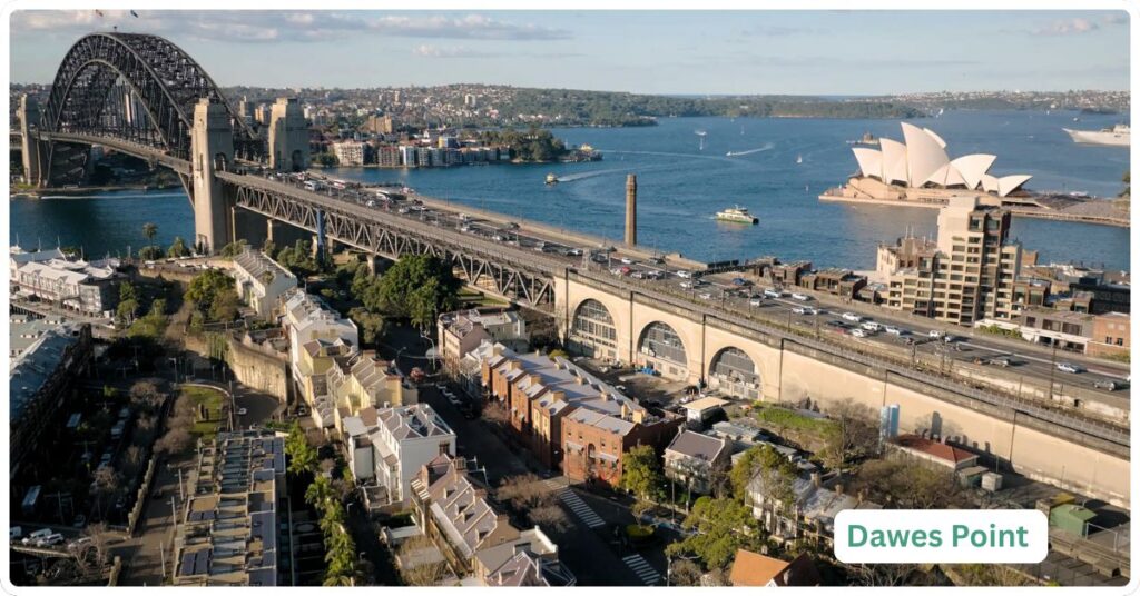
Ask anyone who actually lives in Dawes Point and the picture that comes back is consistent: quiet, insular, walkable to everywhere that matters, and almost entirely self-sufficient in nothing. It suits people who have already made their money and want a harbour address to show for it, or long-term residents in heritage-protected terraces who have watched tourists photograph their front door for decades. It does not suit anyone who needs a school run, a supermarket trolley dash, or a childcare drop-off inside their own suburb, because none of those things exist here.
With the CBD on one side and the Walsh Bay arts precinct on the other, Dawes Point residents skew heavily toward professional and creative work. The 2021 Census recorded 39% of employed residents working as professionals, 63.1% holding a bachelor’s degree or above, and 61% working from home on Census day, a figure inflated by the pandemic snapshot but consistent with a suburb full of people who can walk to a CBD office when they need to and don’t when they don’t. Median weekly household income was $4,708 at the same Census, well above the Sydney metropolitan median, reflecting a resident base with substantial existing wealth rather than one built on local employment opportunities, because there aren’t any to speak of beyond the arts venues themselves.
Shopping & Eating Out
There is no shopping strip, supermarket or retail centre in Dawes Point, and there is no realistic prospect of one given the heritage constraints and the tiny resident base. What the suburb does have, right at its eastern edge along Hickson Road, is the Walsh Bay wharves, home to the Sydney Theatre Company, the Wharf Theatre and the Roslyn Packer Theatre, alongside a pocket of pre- and post-theatre dining: Walsh Bay Kitchen, the Gantry at Pier One Sydney Harbour, and a scatter of bars and cafes servicing the arts crowd rather than a resident shopping public. It’s worth being precise here, because the point gets blurred online: the well-known heritage pubs often associated with this pocket of the harbourside, the Hero of Waterloo and the Australian Heritage Hotel, both sit on Lower Fort Street just over the boundary in The Rocks, not inside Dawes Point itself. For groceries, chemist runs or anything resembling a weekly shop, residents walk into The Rocks or the CBD; there is nothing to do that errand within the suburb.
Recreation, Parks and Green Space
Dawes Point Park, sitting directly beneath the bridge pylon on the site of the old observatory and battery, is the suburb’s green heart and doubles as one of the better free vantage points in Sydney for bridge and Opera House photographs. Hickson Road Reserve runs along the water nearby, and the Harbour Bridge Pylon Lookout, reached via the Cumberland Street stairs, gives access to the pedestrian walkway and cycleway across the bridge deck itself. Barangaroo Reserve, the large harbourside park built on the former container terminal site, is a short walk west and functions as the suburb’s default option for anyone wanting open lawn or a longer harbourside walk, since Dawes Point itself has no space for that.
Transport Services
There is no train station in Dawes Point, and there never will be given the suburb’s size and heritage protections. Wynyard station is the closest, a 15-18 minute walk down Lower Fort Street and through The Rocks or the CBD grid, and it puts you on the T1 North Shore & Western Line among others. Circular Quay is a similar walk in the other direction, useful for the T3, T4, T8 and T9 services as well as ferries. The nearest ferry access is around Barangaroo and the Walsh Bay wharves, a short walk west, rather than anywhere inside Dawes Point itself. There is no light rail stop in or near the suburb; the closest L1 stops are around Circular Quay and George Street in the CBD. Buses along Cumberland Street and through The Rocks connect to the wider network, covered in more detail on our public bus page, but most residents here walk rather than wait for a bus that only needs to cover a few hundred metres. Cyclists and pedestrians can join the Harbour Bridge’s dedicated cycleway and walkway from the Cumberland Street stairs, which also lead up to the Pylon Lookout, meaning the suburb effectively functions as the walk-on point for one of Sydney’s most-used tourist and commuter crossings.
Healthcare Services
Dawes Point has no GP surgery, pharmacy or medical centre of its own. Residents rely on general practices scattered through The Rocks and the CBD, most within a 10-15 minute walk. The nearest major public hospitals are Sydney Hospital and the adjoining Sydney Eye Hospital on Macquarie Street, roughly 1.5km away, with St Vincent’s Hospital in Darlinghurst the next significant public facility beyond that for anything requiring a broader range of services. There is no dedicated aged care facility within the suburb, which matters given the resident population’s median age of 55, well above the NSW median of 39 (2021 Census).
Schools and Childcare
There is no school inside Dawes Point, government, Catholic or independent. The nearest zoned government primary is Fort Street Public School, perched on Observatory Hill in neighbouring Millers Point, one of the oldest continuously operating public schools in Australia, and a strong drawcard for the handful of families in the surrounding harbourside suburbs. Beyond that, families typically look toward CBD-fringe independent and selective options rather than anything walkable. Childcare is the honest weak point. Postcode-matched directories list large numbers of “Dawes Point” long day care and preschool services, but almost all of those addresses sit in Barangaroo towers, Millers Point or the broader CBD rather than inside the suburb’s actual boundary. In practical terms, a family living here is doing childcare drop-offs somewhere else entirely, and should factor that into any decision to buy or rent. Given the 2021 Census recorded 127 families in the suburb, with couples without children making up 66.1% of them and couples with children only 24.4%, this is not a suburb the market has organised itself around raising children.
Crime and Safety
There is no suburb-specific crime data for a resident population this small, and none should be invented. The relevant figure is the City of Sydney LGA, which recorded 42,013 criminal incidents in the year to March 2026, a rate of 19,852 per 100,000 people (BOCSAR), above the NSW average and broadly steady to slightly down over the past decade. Theft dominates the LGA’s numbers (13,328 incidents), followed by assault (4,436) and robbery (181). It’s important to read this in context rather than as a verdict on Dawes Point itself: the LGA figure captures the entire CBD, Kings Cross and the broader entertainment and tourist districts, all of which carry far higher foot traffic and far higher theft and assault exposure than a residential pocket of a few hundred people under a bridge. Anecdotally, long-term residents describe the suburb itself as quiet, with most safety concerns limited to the usual tourist-area pickpocketing risk around the Pylon Lookout and Walsh Bay rather than anything resident-directed.
Realty Market
Dawes Point is one of the few Sydney suburbs where the honest answer to “what’s the median house price” is that there isn’t a reliable one. CoreLogic data (via Your Investment Property) records just 3 house sales and 6 unit sales in the 12 months to May 2026, with no median value, no quarterly growth figure and no annual growth figure published for either property type, because the sample is too thin to produce one that means anything. Anyone quoting a precise median for this suburb is either estimating from a handful of transactions or drawing on a period that has since gone stale; treat any such figure with real caution.
Housing stock is almost entirely heritage terraces and a small number of low-rise apartment conversions, much of it managed under NSW heritage listings that constrain renovation and redevelopment. The 2021 Census tenure split shows 41.2% of dwellings owned outright, 19.4% mortgaged and 34.7% rented, with a notably high 35.4% of the 273 private dwellings recorded as unoccupied on Census night, likely a mix of holiday-style use, corporate housing and properties held rather than lived in day to day. On rentals, the same Census recorded a median weekly rent of $1,450, and the more recent CoreLogic data puts the median unit rent at $1,400 a week with a unit rental yield of just 2.31%, low even by inner Sydney standards and a signal that pricing here is driven by capital value and scarcity rather than by rental return. This is not a suburb to approach chasing yield.
Our Thoughts on Dawes Point
Dawes Point suits a narrow but specific buyer: someone who already has the CBD as their daily orbit, who wants a heritage property with a harbour and Bridge outlook that very few Sydney addresses can offer, and who has no need for a school, a childcare centre or a supermarket inside their own postcode. Empty nesters, well-resourced downsizers and buyers for whom position and history outweigh convenience will find real value here that a generic waterfront suburb can’t match. It is likely to appeal less to young families, who will find no schools, negligible childcare, and a resident base skewed heavily toward couples without children. It’s also less compelling for investors focused on rental yield, given the 2.31% figure and the sheer thinness of the sales data to base a purchase decision on.
The natural comparison is The Rocks, its immediate neighbour and the suburb most buyers cross-shop against it. The Rocks offers a larger resident base, a proper retail and dining strip, and considerably more day-to-day amenity, at the cost of a busier, more tourist-saturated streetscape. Dawes Point trades that amenity away entirely in exchange for quiet, scale, and a more purely residential heritage character. Put simply: choose The Rocks if you want to live somewhere with a pulse of its own; choose Dawes Point if you want to live somewhere that mostly leaves you alone, under one of the most recognisable structures in the country.
Frequently Asked Questions
Is there a train station in Dawes Point?
No. Wynyard and Circular Quay are the nearest stations, both roughly a 15-20 minute walk, and there is no realistic prospect of a station being added given the suburb’s size and heritage constraints.
Is Dawes Point the same as The Rocks?
No, though they’re often confused because they sit side by side and are both governed by the City of Sydney. Dawes Point is the smaller, more purely residential pocket at the very tip of the peninsula under the Harbour Bridge; The Rocks has the bulk of the area’s shops, pubs and tourist infrastructure.
Are the Hero of Waterloo and Australian Heritage Hotel in Dawes Point?
No. Both well-known heritage pubs sit on Lower Fort Street within The Rocks, just across the boundary from Dawes Point.
What is the population of Dawes Point?
385 people at the 2021 Census (ABS QuickStats). No updated suburb-level figure has been published since; new Census data is expected through 2027.
Is Dawes Point a good place to raise children?
Realistically, no. There is no school and no childcare inside the suburb, and the resident population skews heavily toward couples without children. Families here are doing every school run and childcare drop-off outside the suburb.
Why is it called Dawes Point?
After Lieutenant William Dawes, a First Fleet astronomer and marine officer who built Sydney’s first observatory on the site in 1788. The area’s Gadigal name, Tar-Ra, was formally recognised alongside the English name in 2002.
References
- Australian Bureau of Statistics, 2021 Census QuickStats, Dawes Point (SAL11224), accessed September 2026
- NSW Bureau of Crime Statistics and Research (BOCSAR), Local area datasets and Recorded Crime Statistics quarterly update, year ending March 2026
- Sydney Barani, “Dawes Point / Tar-Ra”, accessed September 2026
- Dictionary of Sydney, “Dawes Point” entry, accessed September 2026
- Sydney Theatre Company, Wharf Theatres and Roslyn Packer Theatre venue information, accessed September 2026
- Sydney.com, “A food and drink guide to Walsh Bay”, accessed September 2026
- Pier One Sydney Harbour, venue and dining information, accessed September 2026
- NSW Department of Education, Fort Street Public School, school information, accessed September 2026
- Toddle and CareForKids.com.au, childcare and preschool listings for Dawes Point postcode 2000, accessed September 2026
- Transport for NSW, Western Harbour Tunnel project FAQs and timeline, accessed September 2026
- NSW Spatial Services, NSW Administrative Boundaries Theme, point-in-polygon LGA and postcode verification, September 2026
For more harbourside and inner-city options, browse the full list of Sydney suburbs, or explore the Sydney Regions overview for a broader view of how the city’s pockets fit together.