
Most suburb profiles open by telling you where a place sits and who runs the council. The Rocks doesn’t fit that mould, because it isn’t really a suburb in the way Marrickville or Chatswood are suburbs. It’s a tiny, fiercely heritage-protected residential pocket (629 people at the last count) wedged inside one of the busiest tourist and harbour-front precincts in the country, with the Harbour Bridge overhead, a cruise terminal at its edge and several million annual visitors walking past the front doors of the people who actually live there. That’s the trade-off: cobbled lanes, sandstone terraces and a harbour view most Sydneysiders would sell a kidney for, set against tour groups on your doorstep, market stalls on your street every weekend, and a housing stock so thin and so heavily state-controlled that “buying in The Rocks” barely functions as a normal property transaction. Anyone drawn to the postcard is entitled to know that before they start looking.
The Rocks Boundary and Location Map
The Rocks occupies the sandstone headland on the western side of Circular Quay, right at the harbour’s edge in the City of Sydney local government area. The Sydney Harbour Bridge and Dawes Point mark its northern boundary, Circular Quay and the Sydney CBD sit immediately to the east, the Wynyard end of the CBD borders it to the south, and Millers Point and the newer Barangaroo precinct sit hard against its western edge. In practice, the whole of The Rocks can be walked end to end in about fifteen minutes, which is unusual for a page on this site to have to say out loud.
Quick Facts
| LGA | City of Sydney |
| Postcode | 2000 (confirmed via NSW Spatial Services; a separate, unrelated locality also called “The Rocks” near Bathurst uses postcode 2795 and is not this suburb) |
| Population | 629 people at the 2021 Census (ABS QuickStats, SAL13856); next official figure not due until 2027 results from the August 2026 Census. One of the smallest resident populations of any named Sydney suburb |
| Distance from CBD | Effectively zero. The Rocks is part of the CBD’s northern edge, roughly 1km walk from Town Hall |
| Character | Heritage sandstone streetscape and working harbour history, run largely as a state-managed tourism and hospitality precinct with a small residential population embedded inside it |
| Median House Price | Not meaningfully available. Domain recorded just one 3-bedroom house sale in the trailing 12 months to the accessed date in 2026, too thin for a published median (domain.com.au, accessed September 2026) |
| Median Unit Price | 1-bedroom $1.205m (16 sales) and 2-bedroom $2.275m (11 sales) in the trailing 12 months (Domain, accessed September 2026). Volumes are thin for a full suburb and any figure should be read as indicative, not statistically robust |
| Transport | Circular Quay Station (T1, T2, T3, T4, T8, ferries, light rail) delivered and operating at the suburb’s eastern edge; Barangaroo Metro Station (M1 line) delivered August 2024 a short walk west; Circular Quay Renewal (station and ferry wharf upgrade) still in planning as of January 2026, no construction date set |
| Parks & Recreation | Hickson Road Reserve, Dawes Point Park (Tar-Ra), Observatory Hill, Cadman’s Cottage foreshore walk and the Sydney Harbour Bridge Pylon Lookout, all within or on the edge of the suburb |
| Shopping | The Rocks Markets (Friday street food and weekend arts/gifts markets), Playfair Street and the Argyle Cut dining and retail strip, plus the whole of George Street and the CBD retail core within walking distance |
| Best For | Downsizers, empty-nesters and high-income professionals who want a harbourfront heritage address and don’t mind living inside a tourist attraction; not for families needing schools, playgrounds or quiet streets |
What Makes The Rocks Special
From Convict Ridges to Heritage Precinct
The Rocks’ history is inseparable from that of its neighbour, Millers Point. Francis Pollon’s 1988 history of Sydney’s suburbs treats them as a single joint entry, “Millers Point and The Rocks,” and that’s honest, not lazy: the two grew up together on the same headland. A mill built in 1795 on the site of the present Observatory, owned by Jack Leighton, gave Millers Point its name (Francis Pollon, “The Book of Sydney Suburbs,” 1988). The Rocks itself takes its name from the rising rocky ridges above Circular Quay, which very early in the colony’s history became home to emancipated convicts, free settlers of doubtful means, and sailors ashore on leave (Pollon, 1988). Shoreline rocks were quarried as ship’s ballast for the return voyage to England, and by the 1830s the area had earned a reputation for the so-called “Rocks push” gangs. It remained a working-class, tightly packed dockside neighbourhood for the best part of a century, long before anyone thought to call it heritage.
That working-class character is stamped into the pubs that still trade today. The Hero of Waterloo, built in 1843-44 from sandstone quarried in nearby Kent Street, is said to be one of the oldest hotels still standing in Sydney. The Shipwrights Arms dates from Governor Macquarie’s era (1810-21), and the Lord Nelson in Kent Street, opened in 1834, is reputedly Sydney’s oldest continuously trading hotel (Pollon, 1988). Around them sit some of the city’s oldest surviving buildings: The Ark in Kent Street, a rough stone terrace built by stonemason Thomas Glover before 1820 and reputedly Sydney’s oldest terrace row; Richmond Villa, built in 1849 for colonial architect Mortimer Lewis (1796-1879); and Cadman’s Cottage on Lower George Street, built on the beach in 1815-16 as government boat crew barracks and home to superintendent John Cadman from 1827 to 1845 (Pollon, 1988). Merchant money moved through Campbell’s Storehouses at Circular Quay West, begun in 1842 by Robert Campbell (1769-1846); his son had Bligh House built in Lower Fort Street in 1833, and it still stands. Sergeant Major’s Row in George Street occupies the site of Sydney’s very first street. Two churches from this era survive: Holy Trinity, the Garrison Church (1840), and St Patrick’s Church, Sydney’s oldest surviving Catholic church, consecrated in 1844 (Pollon, 1988).
The area’s turning point wasn’t colonial at all. In 1900, bubonic plague broke out along the Darling Harbour and Millers Point/The Rocks waterfront, one of the few confirmed plague outbreaks in Australian history. The government’s response was large-scale demolition and compulsory resumption of much of the foreshore, followed by a rebuilding program run through the newly created Sydney Harbour Trust from 1901. That single public-health crisis is the reason so much of what survives today is either pre-1900 colonial fabric or early-1900s Federation-era Harbour Trust building stock, with little in between.
By the mid-20th century the precinct had become depressed. In 1967 the NSW Government appointed the Sydney Cove Redevelopment Authority to oversee its preservation and redevelopment, with its first members appointed by December 1969 and work beginning in January 1970. Its brief: preserve and restore historically valuable buildings, create leisure open space, and produce suitable housing for higher-income residents in what had become a rundown area, all while stopping new buildings from crowding the shoreline so the low-to-medium-height character wasn’t lost (Pollon, 1988). Its planning area covered roughly 23 hectares, from Grosvenor Street to Dawes Point and from the Bradfield Highway to George Street. That 1970s conservation-first template, more than any single building, is what The Rocks still looks like today.
A Streetscape Nobody Else Gets to Change
What sets The Rocks apart today isn’t a single attraction, it’s that almost none of the built environment is up for negotiation. Most of the Crown land and many heritage buildings across the precinct are still owned or managed by the state entity legally known as Place Management NSW, now trading publicly as Placemaking NSW. Its heritage and conservation controls, direct descendants of the Sydney Cove Redevelopment Authority’s 1970s brief, dictate what can happen to a sandstone terrace, laneway or shopfront in a way with no real equivalent elsewhere in inner Sydney. The upside: cobbled lanes, working 19th-century pubs, uninterrupted Harbour Bridge and Opera House sightlines from Observatory Hill, and a streetscape that hasn’t been allowed to slide into glass-tower infill. The Rocks Markets, Fridays for street food and weekends for arts, crafts and gifts, are a drawcard, and Playfair Street and the Argyle Cut do a decent job of feeding visitors and the handful of people who live upstairs. It’s a heritage precinct that works because it’s protected, not despite it.
What Is It Like Living in The Rocks Sydney?
Living in The Rocks means accepting that your neighbourhood is also, simultaneously, everyone else’s day trip. Forum chatter from residents and visitors alike lands on the same handful of observations: the views and history are unmatched, foot traffic on Playfair Street and George Street never really stops, and anyone expecting suburban quiet has picked the wrong postcode. It suits people who want to walk to work in the CBD, like the theatre of a working harbour precinct outside their window, and have made peace with living somewhere without a supermarket of its own.
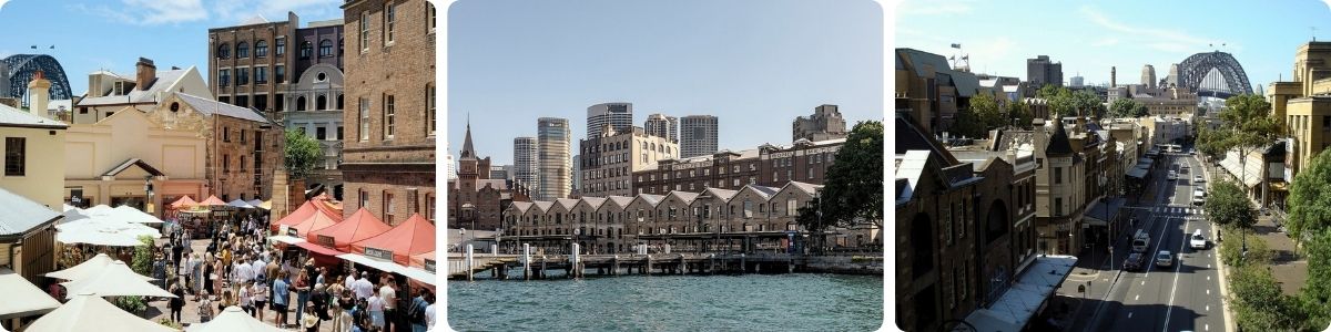
The Rocks’ economy is overwhelmingly tourism and hospitality: hotels, heritage pubs, restaurants, gift and craft retail, market stalls, and harbour cruise and ferry operators working out of Circular Quay. The resident population skews toward professionals commuting a short distance into CBD finance, legal and corporate roles, plus a mix of retirees and long-term social housing tenants whose connection to the area predates its tourist-precinct status by decades. Essentially no local light industry or warehousing remains; the old working-harbour economy is now curated rather than operational.
On the transport front, Circular Quay Station sits on the suburb’s eastern edge and is one of the best-connected single points in the whole Sydney network: T1, T2, T3, T4 and T8 all call there via the CBD interchange, alongside every Circular Quay ferry route and the light rail. Barangaroo Metro Station, on the Sydney Metro M1 line, opened in August 2024 a short walk west and puts Chatswood and the North West within a one-seat ride. Buses along George Street and Argyle Street connect into the wider CBD network. The one live infrastructure item worth flagging is the Circular Quay Renewal project, a rebuilt station, new ferry wharves and public domain works right next door; as of a January 2026 review of the project’s own page it remains in planning and community consultation, with no confirmed construction date.
There’s no hospital inside The Rocks. Sydney Hospital and Sydney Eye Hospital on Macquarie Street is the closest facility, just over a kilometre through the CBD, and St Vincent’s Hospital in Darlinghurst is the nearest major public hospital proper, a short bus or taxi ride away. GP options within the suburb itself are thin given the resident base; most residents and workers use CBD-based general practice clinics a few minutes’ walk away. No dedicated residential aged care facility sits within the suburb; older residents draw on inner-city providers instead.
On the education front, no school inside the suburb, and school-zone premiums simply don’t operate here, because there’s barely a family cohort to zone for. The handful of local children draw on CBD-adjacent public schools and academically selective options such as Sydney Boys High and Sydney Girls High, alongside Catholic options centred on the historic St Patrick’s parish. Childcare directly inside The Rocks is minimal, but can be found across the wider postcode 2000 area, including Barangaroo. Nobody should move here chasing a school catchment; it isn’t built for that.
For fresh produce and some delicious bites, The Rocks Markets on Friday are the place to be and also the broader weekend arts, crafts and gifts market, run under Placemaking NSW’s event program (see The Rocks’ official markets page). Playfair Street and the Argyle Cut carry the suburb’s own dining and retail strip, heavy on heritage pubs and mid-to-high-end restaurants trading on the view as much as the menu. George Street and the wider CBD retail core, plus Circular Quay’s own dining strip, are a two-minute walk away, so residents lean on the CBD for groceries and everyday shopping; there’s no full-line supermarket within the suburb’s own boundary.
For a suburb this small, the open space and attraction list punches well above its footprint. Hickson Road Reserve and Dawes Point Park (Tar-Ra) sit right under the Harbour Bridge with harbour-level views. Observatory Hill, home to the Sydney Observatory, gives one of the best elevated Harbour Bridge and Darling Harbour outlooks in the city. Cadman’s Cottage anchors a foreshore walk along the Circular Quay waterfront, and the Sydney Harbour Bridge Pylon Lookout offers a worthwhile climb-adjacent view without booking a full BridgeClimb. None of it is undiscovered, most of it is free or low-cost, and all of it is walkable in an afternoon.
Realty Market
Buying in The Rocks is not really a normal property transaction, and that has to be said plainly before any numbers are quoted. Much of the land and many buildings across the suburb remain Crown land owned and managed by Place Management NSW (trading as Placemaking NSW), which leases rather than sells much of its heritage stock; some apartments sit on strata title over land the state still ultimately controls under heritage conditions, and some historic terraces are held under long-term Crown leasehold rather than conventional freehold. Anyone seriously considering a purchase needs to establish the exact tenure of a specific property before going anywhere near a contract, because it materially changes what “ownership” means.
Within that context, sales volumes are thin. Domain recorded 16 one-bedroom unit sales at a median of $1.205 million and 11 two-bedroom unit sales at a median of $2.275 million in the trailing 12 months to the date accessed in 2026, with three-bedroom unit sales (8 in the period) too few to support a published median. House sales are effectively non-existent: just one three-bedroom house changed hands in the same window, nowhere near enough to construct a meaningful median (Domain, accessed September 2026). No reliable annual percentage change figure is available given these volumes, and any number quoted elsewhere for The Rocks should be treated with real caution.
The rental market runs on the same logic: small, unit-dominated and driven by proximity to the CBD and harbour rather than normal suburban demand. At the 2021 Census, 57.5% of occupied dwellings in The Rocks were rented, against 25.8% owned outright and 11.6% owned with a mortgage (ABS, 2021 Census, SAL13856), a tenure mix that points to a market shaped as much by state housing and short-stay lets as by conventional tenancies. This is likely to appeal most to renters and downsizers who place a high priority on a harbourfront heritage address and are comfortable with a thin market; it is less compelling for anyone chasing rental yield, given the entry prices and the scarcity of comparable sales.
Our Honest Verdict
The Rocks is not a suburb for people who want a normal life with a normal commute and a normal Saturday. It’s a heritage museum piece that a few hundred people happen to live inside, and it works brilliantly for a narrow set of people: retirees and downsizers who’ve already raised families elsewhere and now want harbour views and history on tap, high-income professionals who want to walk to a CBD desk in ten minutes and don’t mind sharing their street with cruise-ship passengers, and long-term social housing tenants whose ties to the area go back generations. It does not work for families chasing a school catchment, anyone who wants a supermarket within an easy walk, or buyers hoping for a conventional freehold transaction with a clean comparable-sales history: the tenure complications and wafer-thin sales volumes make this one of the hardest property markets in Sydney to read with confidence.
The comparable suburb here is Sydney CBD itself, immediately next door and sharing much of the same proposition (walk-to-everything, apartment-only living, minimal green space, tourist density) at a meaningfully larger scale: roughly 27,936 residents at the 2021 Census against The Rocks’ 629, and a median unit price around $1.698 million against The Rocks’ one and two-bedroom medians of $1.205 million and $2.275 million. Sydney CBD offers more choice, more supermarkets, and a far deeper sales market to benchmark against; The Rocks offers a heritage streetscape and a harbour outlook the CBD can’t match at any price.Choose The Rocks for the history and the view. Choose Sydney CBD for the daily convenience The Rocks can’t offer at its current size. Other nearby suburbs worth comparing are Zetland, Darlington, Glebe, Haymarket, and Potts Point.
Frequently Asked Questions
Is The Rocks in Sydney the same place as “The Rocks” near Bathurst?
No. A separate, unrelated locality also called The Rocks sits near Bathurst, in postcode 2795. This page covers The Rocks in the City of Sydney, postcode 2000, confirmed via NSW Spatial Services boundary data and ABS Census area code SAL13856.
Why do Millers Point and The Rocks share so much history?
Because they grew up as one and the same waterfront precinct. Francis Pollon’s 1988 “The Book of Sydney Suburbs” treats them as a single joint entry, and the landmarks (the Lord Nelson and Hero of Waterloo hotels, Campbell’s Storehouses, the Sydney Harbour Trust rebuilding after the 1900 plague outbreak) belong to both areas at once. Today they’re recognised as separate named suburbs, but the shared history is real.
Do I actually own the land if I buy an apartment in The Rocks?
Not always in the way you’d expect. A large share of land and buildings across The Rocks remains Crown land owned and managed by Place Management NSW, which now trades as Placemaking NSW, and some properties sit under Crown leasehold or heritage-conditioned title rather than conventional freehold strata. Always confirm the exact tenure of a specific property with a solicitor before treating any listing as a standard freehold purchase.
Is The Rocks safe to live in?
BOCSAR only publishes crime data at the City of Sydney LGA level, and that LGA’s raw incident numbers are inflated by an enormous non-resident tourist and nightlife population rather than reflecting risk to The Rocks’ small resident base. There’s no suburb-specific figure for The Rocks, and none should be trusted if quoted elsewhere. Check BOCSAR’s own LGA tool for current numbers and read the context above before drawing conclusions.
Is The Rocks a good place to raise a family?
Realistically, no. Only 6.8% of residents are aged under 15 (ABS, 2021 Census), there’s no school inside the suburb, no dedicated playground-heavy family infrastructure, and no supermarket within the suburb’s own footprint. Families wanting a CBD-adjacent lifestyle with family friendly amenity are generally better served elsewhere in or near the City of Sydney LGA.
When will the Circular Quay Renewal project actually happen?
As of mid 2026, Circular Quay Renewal (covering the station, ferry wharves and public domain immediately next to The Rocks) remains in the planning and community consultation phase, with no confirmed construction start date, completion date or public budget. Anyone factoring it into a near-term decision should treat it as an unconfirmed future project, not a delivered upgrade.
References
- Francis Pollon, “The Book of Sydney Suburbs,” 1988 (Millers Point and The Rocks entry)
- Australian Bureau of Statistics, 2021 Census QuickStats, The Rocks (Sydney – NSW), SAL13856, accessed September 2026
- Domain, “The Rocks NSW 2000, Suburb Profile & Property Market Trends,” accessed September 2026
- NSW Spatial Services, NSW Administrative Boundaries Theme, suburb and LGA boundary query, accessed September 2026
- Transport for NSW, “Circular Quay Renewal” project page, reviewed 19 January 2026, accessed September 2026
- Sydney Metro / NSW Government media releases, Barangaroo Station opening, August 2024, accessed September 2026
- NSW Bureau of Crime Statistics and Research (BOCSAR), NSW Recorded Crime Statistics quarterly updates, December 2025 and March 2026 releases, and LGA Crime Tables/Crime Tool, accessed September 2026
- NSW Department of Communities and Justice / Land and Housing Corporation, Millers Point Program materials, accessed September 2026
- Placemaking NSW (Place Management NSW), Annual Report 2024-2025, and NSW Planning Portal heritage and conservation pages, accessed September 2026
- healthdirect.gov.au, GP service search for postcode 2000, accessed September 2026
- Sydney Info, Sydney CBD suburb profile, sydneyinfo.net.au/sydney-regions/suburbs/sydney-cbd/, accessed September 2026
For more inner-city options to weigh up against The Rocks, browse the full list of Sydney suburb profiles, or explore the broader Sydney Regions overview to see how this part of the city fits alongside the rest of Greater Sydney.