
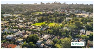
St Peters spent most of the twentieth century as a hole in the ground. Brick kilns, clay pits and rail sidings did the work here while more photogenic suburbs got the postcards, and the scars of that history are still visible if you know where to look: warehouse shells now selling flat whites, a former brickworks now the biggest park in the inner west, and a motorway interchange humming somewhere underneath it all. The trade-off is real and worth stating plainly. You get 44 hectares of open green space on your doorstep and inner-west proximity, but you also get a suburb with almost no shopping strip of its own, a rail service that only partly compensates for decades of industrial planning, and a stretch of Princes Highway that never quite stops being a truck route. St Peters has been reinvented. It hasn’t been prettified, and that’s arguably the point.
St Peters Boundary and Location Map
St Peters sits roughly 6 kilometres south of the Sydney CBD, squeezed between Sydney Park and the Princes Highway, with Alexandria to the north, Tempe and Sydenham to the south, Erskineville to the east and Marrickville to the west. The suburb falls within Inner West Council, though its single biggest asset, Sydney Park, is actually managed by the City of Sydney, a quirk of old municipal boundaries that residents mostly shrug off since the grass doesn’t care who mows it. The WestConnex M4-M5 Link tunnels run beneath the suburb’s northern edge on their way to the interchange with the New M5, which is the other thing St Peters is now known for.
Quick Facts
| LGA | Inner West Council/City of Sydney |
| Postcode | 2044 |
| Population | 3,629 (2021 Census, ABS). No official update since; next Census due 2026. |
| Growth Rate | Up 15.4% between 2016 (3,145) and 2021 (3,629), ABS Census |
| Distance from CBD | Approximately 6km south of the Sydney CBD |
| Character | Post-industrial inner west suburb: warehouse conversions and park frontage on one side, working highway and motorway infrastructure on the other |
| Median House Price | Around $1.85m to $2.01m depending on source (CoreLogic via Your Investment Property Mag, $1,852,000, up 7.99% year-on-year to September 2026; htag.com.au reports $2,012,000, up 3.47% year-on-year) |
| Median Unit Price | Around $941,000 (CoreLogic via Your Investment Property Mag, September 2026, down 3.83% year-on-year off a thin sales sample) |
| Transport | St Peters railway station is in-suburb on the T8 Airport & South Line; Sydenham (T4, T8 and Sydney Metro) and Erskineville (T8) are both a short walk or bus ride away |
| Crime Rate (LGA) | Inner West Council recorded 62.67 offences per 1,000 residents in 2025, down 4.11% on 2024, with violent crime risk below the NSW average |
| Childcare Availability | Tight in-suburb (a small handful of centres), supplemented by a wider pool in Erskineville, Newtown and Alexandria |
| School Zone Quality | One small local public primary (St Peters Public School) with a tight catchment; no public high school in-suburb, families draw on nearby Inner West and City of Sydney secondary options |
| Parks & Recreation | Sydney Park (44 hectares, former brick kiln and quarry site, wetlands, cycling and off-leash areas), managed by the City of Sydney |
| Shopping | Minimal in-suburb; residents lean on Erskineville’s King Street strip, Newtown or the Alexandria big-box precinct |
| Health | No hospital in-suburb; Royal Prince Alfred Hospital, Camperdown is the nearest major public hospital; GPs are concentrated in neighbouring Erskineville and Newtown |
| Best For | Professionals and couples who want inner west access, park frontage and are comfortable with a thin retail strip and the ongoing hum of motorway infrastructure nearby |
What Makes St Peters Special
Most inner Sydney suburbs trade on heritage terraces or harbour glimpses. St Peters trades on having turned its industrial scars into its two most distinctive features, and it is worth understanding both before deciding whether that appeals.
Sydney Park and the Brick Kiln Heritage
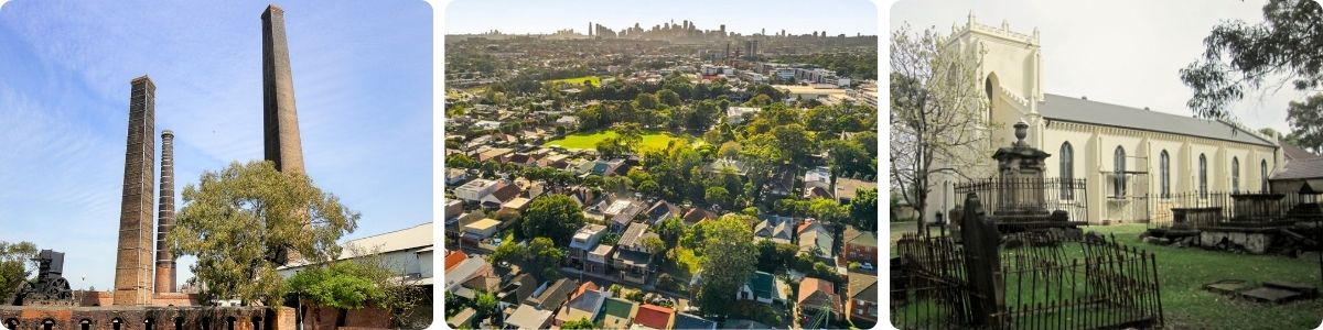
Sydney Park occupies the site of what was, from the 1870s through to the 1970s, one of Sydney’s largest brick and clay pit operations, principally the Bedford Brickworks and Austral Brick Company works. When the clay ran out and the pits were used as a landfill for a period, the land was progressively rehabilitated into what is now the third-largest park in inner Sydney, at roughly 44 hectares. Two of the original chimney and kiln structures still stand at the corner of Princes Highway and Sydney Park Road, heritage-listed and increasingly used for community and arts events rather than left to rust behind a fence. The park’s wetlands, built as part of a major stormwater harvesting project, do double duty: they capture and treat urban run-off for irrigation and they’ve become one of the better bird-watching spots in the inner west. It’s a rare case of an eyesore becoming the actual reason people choose to live nearby, and it’s worth flagging that the park itself is technically a City of Sydney asset rather than an Inner West Council one, even though most of its boundary sits against St Peters.
The WestConnex Interchange Underneath
St Peters is also the endpoint of one of the largest and most contested pieces of transport infrastructure NSW has built this decade. The New M5 tunnels surface at St Peters, and the WestConnex M4-M5 Link tunnels, which run from Haberfield and the Rozelle Interchange, connect into that same interchange beneath the suburb. The M4-M5 Link tunnels opened to traffic in February 2023, ahead of schedule, completing the underground link between the M4, the M5 and the Anzac Bridge corridor. Inner West Council fought hard against aspects of the design during planning, particularly the unfiltered ventilation stack sited at St Peters and years of construction traffic, noise and dust through residential streets. That construction phase is over, but the interchange and its stack are now permanent neighbours.
What Is It Like Living Here?
Ask people who actually live in St Peters what it’s like and the answer tends to split cleanly in two: those who use Sydney Park daily and think the trade-off is more than worth it, and those who moved in expecting Newtown-adjacent convenience and found a suburb with barely a corner shop. Both are honest reactions. It’s a small, dense, park-anchored suburb with limited retail of its own, which means daily life leans heavily on its neighbours.
The brickworks and heavy rail sidings are gone, but St Peters hasn’t entirely shaken its working-suburb identity. Light industrial and warehouse uses persist along the Princes Highway and Campbell Road corridor, though many of the old sheds have been converted into offices, self-storage, small breweries and fit-out businesses rather than manufacturing. Census data shows the resident population skews heavily towards professional occupations, with a median household income around $152,000 a year, well above the Sydney median, and residents commuting into the CBD, Sydney University precinct or Alexandria’s tech and creative office clusters rather than working locally. The result is a suburb that still looks industrial in parts of its built form but functions, demographically, as a commuter suburb for well-paid inner city workers.
Shopping and Eating Out
St Peters is honestly light on its own retail. There’s a scatter of cafes and a handful of newer hospitality openings along Princes Highway and around the light-industrial precinct, some of them repurposed warehouses, but nothing resembling a proper high street. For a real shopping and dining strip, residents walk or cycle into Erskineville’s King Street stretch, with its pubs and long-running cafes, or continue a little further to Newtown, one of the inner west’s busiest dining and retail precincts with everything from cheap eats to established restaurants. Alexandria’s bulky goods and homewares precinct, plus a Woolworths and other everyday retail, is also within easy reach for a proper grocery shop. It’s a suburb where you’ll do your daily coffee locally and your weekly shop somewhere else.
Transport Connections
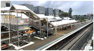
St Peters does have its own railway station, on the T8 Airport & South Line, which is a point of difference from what an outsider might assume of a former industrial suburb. Trains run direct to the CBD via Sydenham and Erskineville, with a journey of around 15 to 20 minutes into Central depending on the service pattern. Sydenham Station, one stop away, is the bigger interchange: it carries the T4 Eastern Suburbs and Illawarra Line and T8 as well as Sydney Metro services, and from mid-October 2026 the former Bankstown heavy-rail line through Sydenham is due to complete its conversion to a Metro rapid transit line, adding another turn-up-and-go option for anyone commuting west. Erskineville Station, also on the T8 line, is a short walk from St Peters’ eastern edge. Buses run along Princes Highway and connect into Newtown and the city, but they’re a secondary option rather than the backbone here; this is a suburb where owning a car remains useful given the WestConnex on-ramps nearby, even though the rail options are better than the suburb’s industrial reputation would suggest.
Healthcare Services
There’s no hospital in St Peters and no realistic prospect of one. GPs are thin on the ground in-suburb; most residents register with a practice in Erskineville, Newtown or St Peters’ Princes Highway commercial strip. For anything more serious, Royal Prince Alfred Hospital in Camperdown is the default major public hospital, roughly a 15 to 20 minute drive or a train-and-bus combination away via Sydenham or Newtown. St George Hospital in Kogarah and Canterbury Hospital are also within reasonable range for specific specialties. It’s not a healthcare desert, but it’s not a suburb where you can walk to a GP either.
Schools and Childcare
St Peters Public School is the local government primary, a small school serving a tight in-suburb catchment given how few residential streets the suburb actually has. There is no public high school within St Peters itself; families typically zone into nearby Inner West or City of Sydney secondary schools, or look at independent and Catholic options across Newtown, Marrickville and Erskineville. Childcare follows the same pattern as schools: there are a handful of long day care and preschool options actually within St Peters, including a council-run community preschool and a couple of private centres, but demand across the inner west generally outpaces supply, and most families end up drawing on the larger pool of centres in Erskineville, Newtown and Alexandria as well. Don’t assume you’ll walk your toddler to care three doors down; budget for a short drive or pram walk instead.
Attractions, Parks and Green Space
Sydney Park is the reason most people who move here, move here. At 44 hectares it dwarfs almost every other green space in the inner west, with cycling and walking loops, a skate park, off-leash dog areas, sports fields, a nursery, and the heritage brick kiln precinct at its Princes Highway corner, which now hosts community and arts events rather than sitting derelict. The park’s constructed wetlands are a local drawcard for birdwatching and a working piece of stormwater infrastructure at the same time. Beyond the park, St Peters has limited standalone attractions of its own, but its position means Erskineville’s pub and cafe scene, the Cooks River foreshore path towards Tempe, and Newtown’s arts and live music venues are all a short trip away.
Crime and Safety
Suburb-specific crime data isn’t published; the only reliable figures are at the Inner West Council LGA level from BOCSAR. On that measure, Inner West recorded around 62.67 offences per 1,000 residents in 2025, down 4.11% on the year before, with theft the single most common offence category ahead of justice procedure matters and assault. Violent crime risk in Inner West sits below the NSW average (roughly a 1-in-104 chance of being a victim locally versus 1-in-83 statewide). None of this is a suburb-specific figure for St Peters itself, and residents online occasionally flag anecdotal concerns about break-ins near the light-industrial strip and antisocial behaviour around Sydney Park at night, which should be read as exactly that: anecdotal, not data.
Realty Market
Buying in St Peters means buying into a small, tightly held market. CoreLogic data reported via Your Investment Property Magazine puts the median house price at $1,852,000 as of September 2026, up 7.99% year-on-year, off a thin sample of around 33 house sales in the preceding 12 months. Another industry source, htag.com.au, puts the median closer to $2,012,000, up 3.47% year-on-year, illustrating how much variance small-sample suburb pricing can produce depending on the exact mix of properties that sold in any given period. Either way, the trajectory is clearly upward from the sub-$1.8 million levels the suburb was sitting at only a couple of years ago. The unit market tells a different story: a median around $941,000, down 3.83% year-on-year, off a slightly larger sample of around 42 sales, suggesting the semi-detached and warehouse-conversion stock is holding value better than standard apartment stock. Housing stock itself is a real mix: 2021 Census data shows flats and apartments at 39%, semi-detached and townhouses at 37.5%, and separate houses at just 22.4%, a dramatically more medium-density profile than the NSW average of around two-thirds separate houses.
The rental market is active and renter-heavy: Census data records 45.4% of dwellings rented, well above the NSW average of 32.6%, against 34.8% owned with a mortgage and 18.1% owned outright. Reported weekly rents sit around $1,000 for houses and $880 for units, translating to gross rental yields of roughly 3.0% for houses and 4.5% for units, figures that suit an income-focused investor better on the unit side than the house side. This is a landlord-friendly suburb in the sense that tenant demand is consistent, driven by the park frontage and rail access, but it’s less compelling for investors primarily focused on capital-growth certainty given how thin and volatile the sales sample can be from quarter to quarter.
Our Honest Verdict
St Peters suits a fairly specific buyer or renter: someone who wants inner west positioning and puts real weight on having a 44-hectare park at their doorstep, and who is comfortable running most errands somewhere else. It suits professional couples and downsizers more than young families chasing a big backyard, given the housing stock is dominated by units, semis and converted warehouses rather than standalone houses with garden space. It suits someone who already owns a car or is happy relying on the T8 line rather than someone who wants a dense, walkable high street on their own doorstep, because St Peters simply doesn’t have one.
It doesn’t suit anyone who wants distance from major infrastructure. The WestConnex interchange sits directly beneath parts of the suburb, and while the worst of the construction disruption is behind it, the ventilation infrastructure and the general character of a suburb built around a motorway junction and a highway aren’t going anywhere. It’s also not the pick for anyone chasing a big, established family home; that buyer is generally better served in neighbouring Erskineville, which offers a comparable inner west, park-adjacent, T8-line position with a stronger retail and dining strip on King Street, at broadly similar or slightly higher price points depending on dwelling type. St Peters is the suburb for someone who wants Erskineville’s location without Erskineville’s terrace-house heritage premium, and who is willing to trade a corner shop for a brick kiln.
Frequently Asked Questions
Does St Peters have its own train station?
Yes. St Peters railway station is within the suburb on the T8 Airport & South Line, with direct services to Central via Sydenham and Erskineville. It’s a smaller, quieter station than Sydenham or Newtown, but it is in-suburb rather than a walk away.
Is St Peters in the City of Sydney or Inner West Council?
St Peters sits within Inner West Council. The common confusion comes from Sydney Park, the suburb’s main attraction, which is actually managed by the City of Sydney rather than Inner West Council, even though most of its boundary runs against St Peters.
Is the WestConnex interchange still causing disruption in St Peters?
The major construction phase is over. The M4-M5 Link tunnels opened to traffic in February 2023, ahead of schedule, and the interchange beneath St Peters is now operational rather than a construction site. The permanent legacy is the ventilation infrastructure and additional traffic on approach roads, which residents and Inner West Council raised concerns about during planning.
Is St Peters a good suburb for families with young children?
It can work for families who prioritise green space over a big house, given Sydney Park’s size, but the local school catchment is small and tight, there’s no in-suburb high school, and childcare places are limited. Families wanting a bigger home with a yard and more schooling choice are usually better served further from the inner ring.
What’s the actual difference between St Peters and Erskineville?
Erskineville has a stronger heritage terrace streetscape and a proper pub and cafe strip on King Street; St Peters has more converted warehouse and semi-detached stock, less retail of its own, and closer proximity to the WestConnex interchange. Both share T8 rail access and effectively share Sydney Park as their local green space.
References
- Australian Bureau of Statistics, 2021 Census QuickStats, St Peters (NSW), SAL13659
- NSW Bureau of Crime Statistics and Research (BOCSAR) recorded crime data, Inner West Council LGA, as summarised by RedSuburbs, 2025
- Sydney Metro, Sydenham to Bankstown project page, accessed September 2026
- Transport for NSW, Southwest Link (Sydenham-Bankstown conversion) project page, accessed September 2026
- Inner West Council, WestConnex Stage 3A: M4-M5 Link, Haberfield to St Peters project page
- Arcadis, WestConnex M4-M5 Link Tunnels opens ahead of schedule, February 2023
- City of Sydney, Sydney Park Wetlands: Major Works, Creation and History
- Tonkin Zulaikha Greer, Sydney Park Brick Kilns project page
- NSW Department of Education, St Peters Public School, enrolment and school information pages
- Australian Children’s Education and Care Quality Authority (ACECQA) National Registers, St Peters area childcare service listings
- NSW Spatial Services, NSW Administrative Boundaries Theme, suburb and LGA boundary data
For more inner west and Sydney comparisons, browse the full list of Sydney suburbs or step back for the Sydney Regions overview.