
Strathfield South runs on borrowed infrastructure. Its northern streets sit within a short walk of one of the largest rail interchanges in Sydney and a dining strip that draws people in from across the inner west, and yet the suburb itself has no town centre, no anchor supermarket (for now, see below) and no high street of its own. That is the honest trade-off here: you are buying proximity to Strathfield’s amenity at a materially lower entry price than Strathfield itself, but the further south you live, the more that proximity becomes theoretical rather than practical. A resident on Water Street is a different commute, and arguably a different suburb, to one on Cooke Park’s doorstep.
Strathfield South Boundary and Location Map
Strathfield South sits within the Strathfield Council local government area, immediately south of Strathfield Station and the main Strathfield commercial precinct. It borders Strathfield to the north, Burwood and Croydon to the east, Campsie and Belmore (across the Canterbury-Bankstown LGA boundary) to the south, and Homebush West to the west.
Quick Facts
| LGA | Strathfield Council (Strathfield Municipal Council) |
| Postcode | 2136 |
| Population | 3,636 at the 2021 Census (ABS QuickStats). No verified suburb-level update exists since; the next Census is due in 2026-27. |
| Growth Rate | No suburb-specific trend figure available. Strathfield Council projects the whole LGA growing from an estimated 46,000 to over 60,000 residents by 2041, though most of that density is planned around Strathfield and Homebush, not Strathfield South itself (Strathfield Council, Community and Area Snapshot). |
| Distance from CBD | Approximately 14km west of the Sydney CBD. |
| Character | A quiet, mid-density residential suburb of freestanding houses and older brick blocks, with no commercial centre of its own, sandwiched between Strathfield’s amenity and the Canterbury-Bankstown border. |
| Median House Price | Reported between roughly $2.2 million and $2.56 million across sources as of mid-2026 (CoreLogic via Your Investment Property Magazine, 12 months to May 2026; Elders Real Estate, 2026). The spread itself is a signal: sales volumes are thin (around 49 in a year), so the median jumps around. |
| Median Unit Price | Not meaningfully separable from house price data in the sources checked; unit stock in Strathfield South is limited compared with the apartment towers around Strathfield Station itself. |
| Transport | Strathfield Station (T1, T2, T3, T7, T9, intercity and regional services) sits at the suburb’s northern edge; delivered and fully operational. No metro line runs through Strathfield South itself. |
| Crime Rate (LGA) | Reported at Strathfield Council LGA level only via BOCSAR; no suburb-specific figure exists or is safe to assert (BOCSAR LGA crime tables, updated to mid-2026, next update due September 2026). |
| Childcare Availability | Adequate but not generous: several long day care services operate in and immediately around the suburb, consistent with tight inner-west-wide demand (ACECQA National Register, CareForKids listings, 2026). |
| School Zone Quality | Solid and locally rated: Strathfield South Public School and Strathfield South High School serve the suburb directly, with selective options (Strathfield Girls High School, Homebush Boys High School) accessible nearby. |
| Parks & Recreation | Three suburb-based reserves (Bark Huts Reserve, Begnell Field, Cooke Park), all local rather than destination-scale. |
| Shopping | None within Strathfield South itself; Strathfield’s Boulevarde and Strathfield Plaza precinct is the nearest option, roughly a 15-25 minute walk or a short bus ride from most of the suburb. |
| Health | No hospital within the suburb; Concord Repatriation General Hospital is the nearest major public hospital, roughly 4-5km away by road, requiring a bus/train combination rather than a direct rail trip. |
| Best For | Owner-occupier families wanting Strathfield’s transport and school access at a lower entry price, and buyers comfortable trading a walkable town centre for space and value. |
What Makes Strathfield South Special
Strathfield South’s identity is defined less by what it has than by what it borrows, and by a civic history that most residents drive past without knowing. Two things set it apart from a generic middle-ring Sydney suburb: the sheer scale of the rail interchange on its doorstep, and a name that was deliberately erased and replaced more than a century ago.
From Druitt Town to Strathfield South: a Rewritten Name
Strathfield South was not always called Strathfield South. It began life as Druitt Town, a name honouring Major George Druitt, a friend of Judge Josephson and the man who owned the land on which the settlement was established (Francis Pollon, “The Book of Sydney Suburbs,” 1988). It is worth being precise about scale here: Druitt Town was a small settlement within the broader Strathfield district, not the district itself, so the civic milestones that follow describe that wider area’s early administration rather than events specific to Druitt Town’s own streets.
The district’s local post office first opened under the name “Redfern” in 1881 and was renamed “Strathfield” in 1886 (Pollon, 1988). The area’s first mayor, George Hardie, held office for a little over a year from 1885 (Pollon, 1988). Those are civic facts about the emerging Strathfield district as a whole, folded into the same 1988 account that preserves Druitt Town’s name and origin.
The formal renaming from Druitt Town to Strathfield South is a separate, later, and more precisely dated administrative fact: the NSW Geographical Names Board records the change as taking effect in January 1893, with formal gazettals on 17 December 1992 and 1 December 1995, and the most recent gazettal on 2 June 2023. The Druitt Town name has been gone from everyday use for well over a century, yet the state keeps formally reaffirming the modern name, an unusual amount of bureaucratic attention for a suburb this size.
A Rail Interchange It Doesn’t Have to Build
Strathfield Station sits right at the suburb’s northern boundary, and it is not a minor stop. Eight platforms across four island platforms handle the T1 North Shore & Western Line, the T2 Leppington & Inner West Line, the T3 Liverpool & Inner West Line, the T9 Northern Line and the T7 Olympic Park Line, plus Blue Mountains, Central Coast and NSW TrainLink regional services (Transport for NSW station map, 2026). That is a large amount of rail access to inherit without having to fund or host any of it. It is worth being clear that Strathfield Station’s own services are unaffected by the separate Sydney Metro conversion works underway on the T3 corridor between Sydenham and Bankstown, well to the south; Strathfield sits outside that construction zone entirely (Sydney Metro project updates, 2026). What the interchange does not do is solve the suburb’s internal geography: streets closer to Cooke Park and the Campsie boundary are a bus-then-walk proposition to reach that same station, not the five-minute stroll a Strathfield address gets.
What Is It Like Living in Strathfield South?
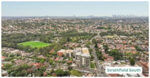
Day to day, Strathfield South reads as a residential holding pattern next to somewhere busier. It is quiet, it is mixed-cultural in a way the 2021 Census data bears out plainly, and it asks residents to accept that almost everything beyond schooling and green space happens just outside its own boundary.
This is a commuter suburb, not an employment node. With Strathfield Station on the doorstep and a fast run into the CBD, most working residents are travelling out each day rather than working locally, a pattern consistent with the suburb’s Census-recorded cultural mix of professional and small-business households drawn from Chinese, Korean, Indian and Sri Lankan communities among others (ABS 2021 Census). Local employment within the suburb itself is limited largely to trades, small retail and services, since there is no commercial or industrial precinct of any scale within Strathfield South’s own boundary.
Strathfield Station, on the suburb’s northern edge, puts residents on the T1 North Shore & Western Line, the T2 Leppington & Inner West Line and the T3 Liverpool & Inner West Line, with journeys to the CBD generally running 15-20 minutes depending on service. Local buses connect the suburb’s southern streets to the station and across to Burwood and Campsie, which matters because those streets are a 15-20 minute walk from the platforms, not a stroll. The Hume Highway (Canterbury Road) and the M4 corridor via Concord Road give reasonable arterial access, though peak-hour congestion around the interchange precinct is a daily reality, not an occasional one.
For healthcare, general practices operate along the suburb’s residential streets and in the surrounding Strathfield and Belfield strips, though there is no single major medical centre within Strathfield South’s own boundary. Concord Repatriation General Hospital, part of Sydney Local Health District, is the nearest major public hospital, roughly 4-5km away by road (Sydney Local Health District transport guide, 2026). Getting there without a car means a bus and train combination, since no rail service runs straight to the hospital precinct. Dedicated large-scale aged care options exist in greater Strathfield, Enfield and Belfield.
Strathfield South Public School and Strathfield South High School serve the suburb directly under the NSW Department of Education’s zoning system (NSW School Infrastructure records, 2026). Strathfield South High School’s own address sits just over the border in Enfield, a small quirk of how the area’s zoning was drawn rather than a reflection on the school itself. For families chasing a selective placement, Strathfield Girls High School and Homebush Boys High School both draw from catchments overlapping the broader Strathfield precinct and carry strong local reputations, though neither guarantees automatic entry from a Strathfield South address: entry to the selective stream is by test, not by zoning.
Childcare supply is adequate rather than generous: several ACECQA-registered long day care services operate in and around the suburb, but demand pressure across the inner west makes early enrolment the sensible move for anyone planning around a return-to-work date.
Strathfield South has no shopping strip of its own, full stop. What it has is proximity: Strathfield’s commercial precinct, centred on The Boulevarde near Strathfield Station and Strathfield Plaza, is recognised locally as something close to a Koreatown, with a dense run of Korean and broader East Asian dining including venues such as Biwon Korean BBQ and Hansang. That precinct is a walk of roughly 15-25 minutes from Strathfield South’s northern streets, or a short bus trip from further south. That changes soon, potentially: a state-significant development application lodged for 72-88 Water Street in Strathfield South proposes an 8-storey mixed-use building with 132 apartments and a full-line supermarket plus specialty retail, an $81.4 million project on public exhibition as of February 2026 (Urban Digest, 2026). If it proceeds, it would be the first piece of local commercial floorspace the suburb has had.
Locally, Strathfield South has three council-maintained reserves: Bark Huts Reserve (4.05 hectares, Elliot Street), Begnell Field (4.24 hectares, at Madeline Street and Cosgrove Road, used for rugby league and other field sports), and Cooke Park (at Madeline and Chisholm Streets, one of the suburb’s larger and more popular green spaces) (Strathfield Council parks directory, 2026). None of these is a destination park; they are neighbourhood-scale sporting and recreation grounds, which suits everyday use more than a weekend outing. For a bigger day out, Sydney Olympic Park is accessible via the nearby T7 line, though it sits outside the suburb itself.
BOCSAR publishes crime data at the Strathfield Council local government area level, not suburb by suburb, so there is no verified Strathfield-South-specific crime rate, and it would be dishonest to imply one exists. At LGA level, Strathfield’s crime tables are maintained by the NSW Bureau of Crime Statistics and Research and updated periodically (most recently mid-2026, with the next scheduled update in September 2026). Anecdotal, unverified local sentiment on community forums tends to describe Strathfield South as unremarkable on safety, which is worth noting but should be read as exactly that: anecdotal, not a data point.
Realty Market
Buying in Strathfield South means buying into a small, thin market rather than a deep one, and the price data reflects that. CoreLogic figures reported via Your Investment Property Magazine put the median house price at $2,205,000 for the 12 months to May 2026, down 4.13% over that year but up an average of 4.25% a year over the longer term. Elders Real Estate’s own recent figures instead show a median of $2,557,500, up 7.70% over 12 months, from 49 recorded sales, and HTAG data shows a third figure again, around $2,465,000. None of these sources is wrong exactly: with only around 49 sales a year, the suburb’s median swings quarter to quarter in a way Strathfield’s much larger market does not. Housing stock is predominantly freestanding houses and older low-rise brick blocks, with limited unit stock compared with the towers clustered around Strathfield Station itself.
Renting tells a steadier story. Median weekly rent for houses sits between roughly $965 and $999 depending on source, giving a gross rental yield in the low 2% range, which is thin by investment standards and consistent with a suburb where most of the value is priced into the land and the school zone rather than into rental cash flow. That combination (high entry price, low yield) is likely to matter more to an investor chasing income than to an owner-occupier prioritising space and schooling.
Our Honest Thoughts
Strathfield South is likely to appeal most to owner-occupier families who want Strathfield-grade rail access and a solid local school zone without paying Strathfield’s own prices, and who are comfortable that their day-to-day shopping and dining happens a walk or a bus ride away rather than downstairs. It also suits buyers who value quiet, mid-density streets over street life, and who are not fussed about having a town centre of their own, at least until the Water Street development (if it proceeds) changes that equation.
It is a weaker fit for anyone chasing rental yield: at a gross yield in the low 2% range on a house price north of $2 million, the numbers simply do not work as an income play, whatever the longer-term capital growth case might be. It also doesn’t suit buyers who want an evening on foot, a cafe strip, or a supermarket they can walk to today rather than potentially in a few years. For that kind of walkable, dining-forward lifestyle at a comparable transport standard, Strathfield itself is the honest cross-shop, at a real price premium for the privilege of living inside the precinct rather than a walk away from it.
Frequently Asked Questions
Is Strathfield South within walking distance of Strathfield Station?
Only from its northern streets. Homes closer to Cooke Park and the Campsie boundary are a bus-then-walk trip, not a stroll, so proximity to the station should be checked street by street rather than assumed suburb-wide.
Was Strathfield South really called Druitt Town?
Yes. The suburb was originally named Druitt Town after Major George Druitt, the landowner and friend of Judge Josephson on whose land the settlement was established (Pollon, 1988). It was formally renamed Strathfield South, effective January 1893, with the change reconfirmed by gazettal as recently as 2 June 2023 (NSW Geographical Names Board).
Does the T3 Bankstown Line metro conversion affect Strathfield Station?
No. The metro conversion works are confined to the Sydenham-to-Bankstown section of the corridor, well south of Strathfield. Strathfield Station’s own services, including its T3 platform, are unaffected.
Is there a supermarket in Strathfield South?
Not currently within the suburb’s own boundary. A state-significant development at 72-88 Water Street proposes a full-line supermarket as part of a mixed-use apartment building, on public exhibition as of February 2026, but it has not yet been approved or built.
Can I get a suburb-specific crime rate for Strathfield South?
No, and treat any source that claims one with scepticism. BOCSAR reports crime at the Strathfield Council local government area level, not by individual suburb, so any Strathfield-South-specific figure is not a verified statistic.
References
- Francis Pollon, “The Book of Sydney Suburbs,” 1988
- NSW Geographical Names Board, Strathfield South entry (name change effective January 1893; gazetted 17 December 1992 and 1 December 1995; most recent gazettal 2 June 2023)
- Australian Bureau of Statistics, 2021 Census QuickStats, Strathfield South (SAL13691), abs.gov.au
- Strathfield Council, Community and Area Snapshot, strathfield.nsw.gov.au
- Strathfield Council, Parks and Natural Areas directory, strathfield.nsw.gov.au
- Your Investment Property Magazine, Strathfield South NSW 2136 suburb profile (CoreLogic data, 12 months to May 2026)
- NSW Bureau of Crime Statistics and Research (BOCSAR), LGA crime tables, Strathfield Council, updated mid-2026
- Transport for NSW, Strathfield Station public transport map, 2024/2026
- Sydney Metro, T3 Bankstown Line metro conversion project updates, 2026
- Sydney Local Health District, transport guide to Concord Repatriation General Hospital
- healthdirect, Concord Repatriation General Hospital service listing
- NSW School Infrastructure, Strathfield South Public School listing
- ACECQA National Register, Strathfield One-Stop Child Care Service and related long day care listings
- CareForKids.com.au, childcare services listing for postcode 2135/2136
- Urban Digest, “Strathfield South’s $81.4m Supermarket Proposal on Show,” 2 February 2026
For more suburbs across Strathfield Council and the rest of the Inner West, see the full Strathfield LGA suburb list, or step back to the Sydney Regions overview to compare against the rest of the city.