
West Hoxton is what a growth suburb looks like twenty years after the growth stops making headlines. Most of Liverpool’s newest estates, Austral, Denham Court, Catherine Field, are still mid-build, still arguing with the council over infrastructure. West Hoxton did that argument in the late 1990s and early 2000s and has spent the two decades since simply being lived in. The result is a suburb of big double-storey houses on quarter-acre-adjacent blocks, established street trees, and a population that has settled into family life rather than one still watching cranes go up next door.
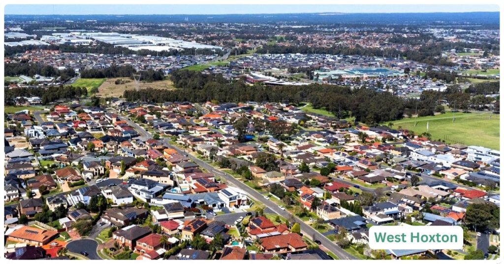
It sits west of Cowpasture Road, wedged between Hoxton Park, Carnes Hill and Middleton Grange, and it shares a shopping strip, a library and a rail line with all three without technically containing any of them. That’s the defining trade-off of the place: everything you need is a short drive away, almost nothing is within it. There’s no town centre inside West Hoxton’s own boundary, no train station, no significant employment base. What there is, is a lot of solid family housing at a price point that undercuts almost anywhere closer to the city with a comparable land size.
It’s also one of the more culturally mixed pockets of south west Sydney, not in the “diverse on paper” sense but in the lived sense: a genuinely broad spread of ancestries and birthplaces packed into fairly uniform housing stock. That’s unusual for a masterplanned-era suburb, and it shapes the place more than the architecture does.
West Hoxton Boundary and Location Map
West Hoxton sits within the City of Liverpool, bounded broadly by Cowpasture Road to the east (separating it from Hoxton Park and Carnes Hill), with Middleton Grange and Denham Court to the south and west. It covers roughly 6.3 square kilometres of largely residential land, developed in successive stages from the late 1990s through the 2000s. The suburb has no significant commercial or industrial zoning of its own; it is almost entirely housing.
Quick Facts
West Hoxton: At a Glance
| LGA | Liverpool City Council |
| Postcode | 2171 |
| Population | 10,152 (ABS 2021 Census, SAL) |
| Median Age | 34 years (ABS 2021 Census) |
| Distance to CBD | Approximately 40km west of Sydney CBD |
| Nearest Station | Leppington (T2 line), several km east via Cowpasture Road and connecting bus |
What Makes West Hoxton Special
An established suburb, not a construction site
Unlike its newer neighbours further out along the South West Growth Area, West Hoxton isn’t mid-build. The estates went in during the late 1990s and 2000s, the trees have grown, the schools are established rather than brand new, and the streets don’t have the raw, freshly-turfed look of Austral or Denham Court a few kilometres away. If you want a finished suburb rather than a decade-long construction zone, that maturity is the actual product on offer here.
Genuinely mixed, not just diverse on a census table
The 2021 Census shows a spread of ancestries, Australian, Italian, English, Indian, Chinese, and a meaningful share of residents born in Iraq, Fiji, the Philippines and Vietnam (ABS 2021 Census, SAL14263). Just under half the suburb speaks only English at home. That mix shows up in the local shops and services more than in the housing itself, which is fairly uniform brick-and-tile family stock.
Land size without the inner-ring price tag
At a median of roughly $1.26 million (2025), West Hoxton houses cost meaningfully less than comparable block sizes closer to the M5 corridor or inner south west, while still delivering the double-storey, four-bedroom, two-car-garage format that’s hard to find under $1 million anywhere within 30km of the CBD.
What Is It Like Living Here?
Living in West Hoxton means accepting the car as the default mode of transport. Almost everything, the supermarket, the library, the leisure centre, is a short drive rather than a walk, because most of that infrastructure sits just over the road in Carnes Hill rather than inside West Hoxton’s own boundary. That’s not necessarily a problem if you’re a two-car family with school-age kids, which is the demographic the suburb is clearly built around. It’s more of a problem if you were hoping for a walkable, station-adjacent lifestyle, because that’s simply not what’s on offer here.
Hospitals
Liverpool Hospital, one of south west Sydney’s major public hospitals, is the nearest significant facility, a drive of roughly 10 to 15 minutes depending on traffic on Hoxton Park Road and Cowpasture Road.
Education
The nearest government primary options are Hoxton Park Public School and Greenway Park Public School, both just outside the suburb boundary. Clancy Catholic College, established in 2005, sits within West Hoxton itself, alongside Thomas Hassall Anglican College nearby. Families chasing a selective high school place look toward the broader south west Sydney network rather than anything local. As with most of the growth corridor, popular local primary schools fill their zones quickly, and it pays to check current enrolment boundaries directly with the NSW Department of Education rather than assuming an address guarantees a place.
Industry & Work Life
West Hoxton has essentially no local employment base of its own; it’s a bedroom suburb. Most residents commute to Liverpool, the broader south west industrial and logistics precincts around Moorebank and Prestons, or further afield into Sydney via Leppington station or the M7 and M5 motorways. The Western Sydney International Airport at Badgerys Creek, still under construction, is likely to reshape employment patterns for the area over the coming decade, though it isn’t yet a factor in day-to-day work life here.
Parks and Natural Spaces
Along the western side of West Hoxton is Western Sydney Parklands, which extends from Leppington all the way north to Quakers Hill, some 27 or so km. There is a fenced dog park, extensive walking trails and Badu Lake offering a peaceful spot to chill by the water.
The Greenway Park offers a community centre and two mixed-use ovals that join to the small Lake Francis. Most of the larger recreational infrastructure, sporting fields, the library, and indoor and outdoor recreation space sit at the Carnes Hill Community and Recreation Precinct just across Cowpasture Road.
Transport
West Hoxton has no train station within its boundary. The nearest is Leppington, on the T2 line, several kilometres to the east; getting there from most of West Hoxton means a car trip or a bus connection rather than a walk. From West Hoxton, bus 852 takes around 40 mins to Liverpool station, whilst by car it’s around 17 mins.
Bus routes 851, 852, 853 and 854 run along Cowpasture Road connecting West Hoxton to Liverpool, and route 859 links toward Edmondson Park station, though frequency drops off outside peak times, which matters if you’re relying on the bus rather than a car for the daily commute.
Cowpasture Road and Hoxton Park Road are the two main arterials through the area, and Cowpasture Road connects directly to the M7 Westlink via the Cowpasture Road interchange, giving reasonably fast access north toward Parramatta or south toward the M5. Camden Valley Way is a short drive south for access toward Narellan and Campbelltown. The suburb sits around 40km west of the Sydney CBD (Wikipedia, citing Australia Post postcode data). Liverpool’s town centre and hospital precinct are a short drive north east; the new Western Sydney International Airport at Badgerys Creek, sits within a similar drive time to the west.
It’s also worth noting Transport for NSW’s “Fifteenth Avenue Upgrade,” part of the broader Liverpool to Airport Transit Corridor, that will have an impact here. The Australian Government has committed $500 million toward the roughly $1 billion project, which will upgrade Fifteenth Avenue as part of an east-west public transport corridor linking Liverpool, the new Bradfield City Centre and Western Sydney Airport, covering about 5.9 km along Fifteenth Avenue between Devonshire Road and Cowpasture Road, plus 2.2 km along Hoxton Park Road between Cowpasture Road and Banks Road.
Realty Market
Median house price sits around $1.26 million as of 2025 (Your Investment Property magazine), with some property-data aggregators tracking it closer to $1.3 million by mid-2026, a roughly 4% annual increase on some measures, though figures vary noticeably between sources, which is common in a suburb with a relatively low volume of annual sales. The market here is overwhelmingly houses; unit sales are rare enough (single figures in a 12-month period on some data sources) that there’s no reliable median unit price to quote. Buyers are typically upsizing families chasing land size and an established street rather than first home buyers, who are more often priced into newer, smaller-lot estates further out.
Whilst West Hoxton is largerly considerd as built-out, there is new growth in pockets and infill. A June 2026 planning application for Lot 2 Fifteenth Avenue, West Hoxton includes a service station, convenience store, McDonald’s, a childcare centre with 90 spaces, and subdivision into 19 residential lots.
The Honest Verdict
West Hoxton is a solid, unglamorous choice for a family that wants an established house on a proper block, is comfortable driving everywhere, and doesn’t need a train station on the doorstep. Weighed against its closest comparisons, Hoxton Park is smaller and cheaper with a more modest housing stock; Carnes Hill has the shopping and recreation infrastructure but less standalone housing of its own; Middleton Grange is newer and pricier with tighter blocks. West Hoxton sits in the middle of that set: bigger houses than Hoxton Park, more established than Middleton Grange, entirely dependent on its neighbours for anything beyond housing. If proximity to a train station matters to your daily life, this isn’t the suburb. If land size and an already-settled street matter more, it’s a genuinely reasonable buy.
Frequently Asked Questions
Does West Hoxton have a train station?
No. The nearest is Leppington, on the T2 line, reached by car or bus connection.
Is West Hoxton a good suburb for families?
The housing stock, mostly four-bedroom, double-storey homes on family-sized blocks, and the presence of established schools like Clancy Catholic College and Thomas Hassall Anglican College nearby, make it a reasonable fit for families who are comfortable driving to most amenities.
What’s the median house price in West Hoxton?
Around $1.26 million as of 2025, according to Your Investment Property magazine; some 2026 tracking sources put it closer to $1.3 million. Figures vary between data providers.
Where do West Hoxton residents shop?
Mostly at Carnes Hill Marketplace on Cowpasture Road, anchored by Woolworths and Big W, which sits just outside the suburb boundary but functions as its de facto town centre.
Is West Hoxton the same as Hoxton Park?
No, they’re separate suburbs, though closely linked historically. West Hoxton developed as an extension of the original Hoxton Park subdivision (named in 1887), with West Hoxton itself first officially recorded in 1922 when residents petitioned for a local post office.
References
Australian Bureau of Statistics, 2021 Census QuickStats, West Hoxton (SAL), released 28 June 2022.
Your Investment Property Magazine, West Hoxton NSW 2171 Suburb Profile, 2025 data.
Liverpool City Council Library, Suburbs of Liverpool: West Hoxton.
NSW Bureau of Crime Statistics and Research (BOCSAR), Liverpool LGA recorded crime data, 2025 quarterly reporting.
Note on crime data: NSW BOCSAR publishes recorded crime statistics at the Local Government Area level, not suburb level, so figures cited for Liverpool LGA reflect the whole council area rather than West Hoxton specifically. Third-party aggregators report Liverpool LGA crime volumes increasing year on year into 2025; readers wanting the primary offence-rate-per-100,000 comparison against the NSW average should consult BOCSAR’s own dashboards directly, as that granular comparison wasn’t able to be confirmed from a single authoritative figure at time of writing.
See all suburbs in the Liverpool City Council. See the full Sydney Regions overview to explore more of greater Sydney.